Vernal pools are little ponds which have no permanent stream entering or exiting. They fill with snowmelt, rain, and groundwater, but in droughty years they often dry out before summer’s end. These characteristics prevent fish from living in vernal pools (fish can’t get to them and fish couldn’t escape when they dry out). This allows animals with little defense against hungry fish to prosper in vernal pools, especially if they can also survive when the pool dries out.
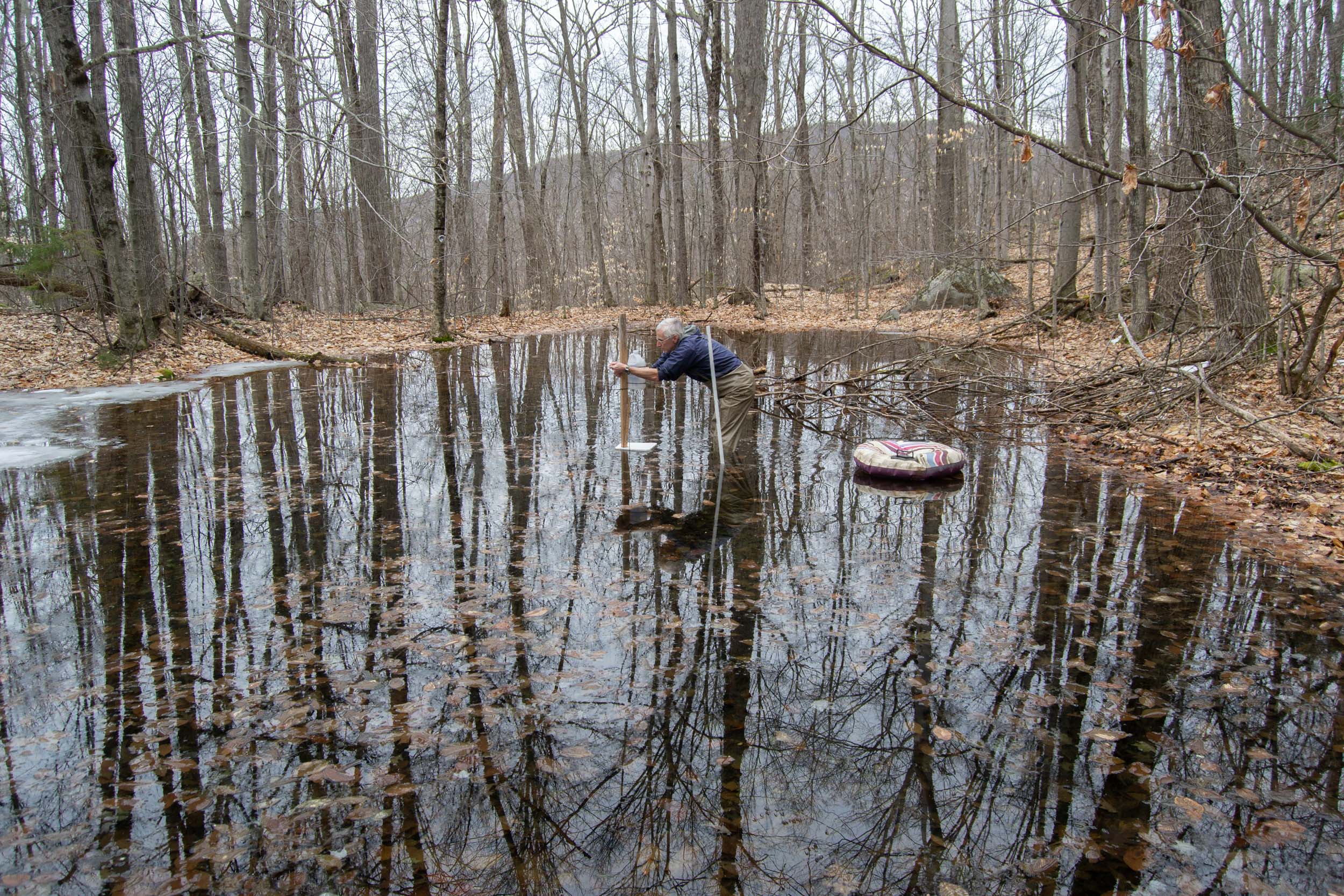
Ned is installing the data logger on a wooden post in about 20 inches of water. There is still some ice at the edge of the pool. March 28, 2020.Continue reading “Vernal pool data logging”
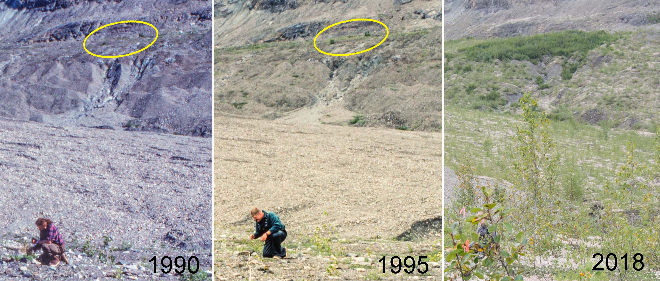
Very few Sitka alders established during the first two decades after the retreating Muir Glacier exposed my youngest study site (Site 1) at Glacier Bay. Older sites in Muir Inlet had abundant alder plants by the time the surface was 20 years old, and it seems likely that the difference was caused by a shortage of alder seeds arriving at the young site. Today there are a few alders at Site 1, and what they have done (or not done) in the last three decades suggests a more nuanced explanation.
View from Plot 1 at Site 1 in three different years. Two Sitka alder plants visible in 1990 (ellipse) produced seeds which formed an island of alder 80 m across by 2018.
The young vegetation on the north side of Upper Muir Inlet in Glacier Bay National Park is developing dramatically differently from older vegetation a few km away. Today, five decades after the retreating Muir Glacier exposed my youngest study site (Site 1) to plant invasion, it supports an open shrubland of willows with most of the ground still carpeted with low-growing Dryas drummondii. At the same age (in 1995), the next older site (Site 2) had no Dryas and was a dense thicket of 6 meter tall Sitka alder shrubs. The distinct successional pathways being followed at these sites have critical ecological differences (e.g., alder is an important nitrogen fixer) and suggest that inferring ecological change from a sequence of different aged sites in this part of Glacier Bay does not work.
Can seed rain explain this?
My favorite hypothesis to explain this is that early seed rain of alder differed between the two areas. Ice margins in Glacier Bay have been retreating to the north for almost three centuries, and invading newly exposed terrain requires that plants can migrate as fast as the ice retreats. Alder was apparently doing a good job of chasing the ice along most of Muir Inlet where my reconstructions of invasion histories at four study sites confirm that alder was an important early invader. Continue reading “When alder can’t keep up”
In the late 1980s, I established vegetation study plots at 10 sites along the eastern side of Glacier Bay in southeastern Alaska. These sites were more or less evenly spaced between the retreating Muir Glacier and the terminal moraine which the Glacier Bay ice had built at the end of the Little Ice Age. The youngest site had been exposed by retreating ice in 1968 and the oldest site had been exposed around 1770 soon after the ice melted back from the 1740 moraine. So on average the age difference between “consecutive” sites was about 20 years (202 years ÷ 10).
There are three approaches to learning things from this series of different aged study sites:
You can assume the sites form a chronosequence so that changes inferred from the series of progressively older sites are also changes that have happened at individual sites. According to this assumption my older study sites would have passed successively through stages similar to all of the younger sites.
You can be less trusting of the chronosequence and use evidence at each site to reconstruct its developmental history. This history can be compared to younger sites and to their histories to test the above assumption. Tree rings and paleoecology are potential sources of information about vegetation history at individual sites.
You can wait until each site attains the age of the next older site at the time of establishment. At that time Site 1 should look just like Site 2 did when you started, and so on. If the chronosequence assumption is valid, each site will have aged predictably and you will have a new, slightly older, and now verified chronosequence. You can have some confidence that inferences about change made from that chronosequence are valid.
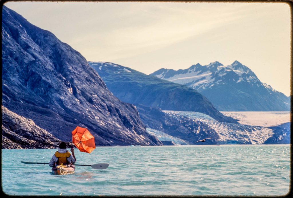
I saw Riggs Glacier on my first trip to Glacier Bay in 1984. Of the three tidewater glaciers in Muir Inlet at that time, only McBride Glacier reaches sea level today. In 1990, as one of the final field tasks for my dissertation, I established permanent study plots between Riggs Glacier and Muir Glacier. This summer Galen and I used old sketch maps to find all five of them and recorded GPS coordinates.
Lewis testing his downwind rig at Riggs Glacier. Kodachrome, July 1984
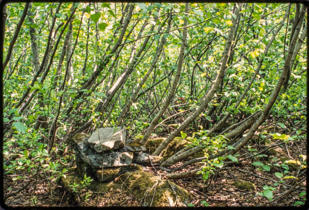
My second youngest study site at Glacier Bay is on a bench of outwash about 150 feet above Muir Inlet. Before alders covered the young surface in the mid 20th century, the bench offered a good view of the retreating face of Muir Glacier to the north. William O. Field established a photo station there maybe in the late 1940s and marked the spot with a cairn assembled of several large rocks. I found the cairn in 1988 when I set up my study plots in a dense thicket of alders.
A photo station cairn built by William O. Field near one of my study plots. This might be Field’s station “6A.” Kodachrome, May 1995
Click photos to enlarge.Stream in Soldiers Delight. I can’t remember exactly where this is. Fall 1973.
As a kid, my favorite thing about Soldiers Delight was playing in the streams. They were very different from all other streams I knew, which were muddy. In Baltimore County walking in a stream generally meant walking in mud. The water in Soldiers Delight streams was clear, and the stream bottoms were mostly stoney. The stream banks were also grassy and sunny. Streams elsewhere could be sunny, but even managed streams through pastures or parks were often lined with a thicket of woody plants. At Soldiers Delight long stretches of streams were lined only with tall grasses and wildflowers. Plus there were minnows and frogs and snakes. These were great streams. Continue reading “Buddles”
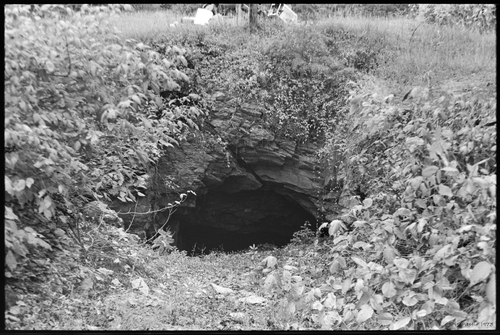
Entrance to the Choate chromite mine at Soldiers Delight in Maryland. Fall 1973.Entrance to the Choate mine. Although trash was being removed from the area, fresh appliances had been dumped above the entrance. Fall 1973.
Soldiers Delight would be a lot less interesting to some were it not for its contribution to the economic history of Baltimore County, Maryland. Serpentine outcrops including Soldiers Delight, Bare Hills, and the State Line Barrens in Pennsylvania supplied most of the world’s chromium ore in the mid 19th century. Issac Tyson, and later his sons, owned land and operated mines at these places, shipping all the chromite to Baltimore and monopolizing the industry from the 1820s until after the Civil War. But the long term impact of this activity may have been more ecological than economic. Continue reading “Arrested development”
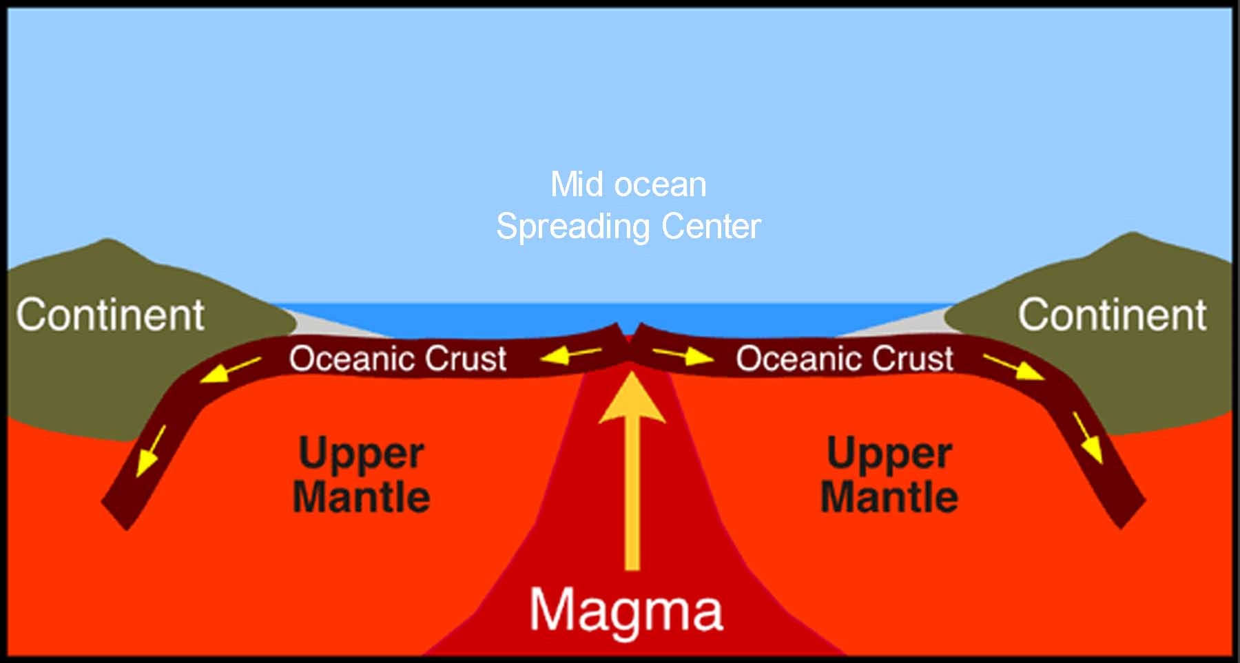
Below is a diagram that was never shown to me in science class. Alfred Wegener proposed his theory of continental drift in 1912, but it was not until 1960 that most scientists began to accept the new paradigm that continents move around. The idea of crust formation at mid ocean ridges came even later in 1966. So when scientists and teachers in the 1950s and 1960s presented a story about the serpentine rock underlying Soldiers Delight, they got it wrong. Serpentinite is formed in the lower oceanic crust, typically at the mid ocean spreading centers. That’s where it picks up its heavy minerals, like chromium, nickel, and magnesium, which are more abundant in the mantle and deep crust. When Africa floated over here 300 million years ago, a little bit of this oceanic rock got pushed along with it and ended up in the Appalachian Mountains, and in Soldiers Delight. Nobody knew that in 1960.
Click images to enlarge
A diagram of magma rising through the mantle and forming new oceanic crust at a mid ocean rise. This is where serpentinite is formed.Continue reading “Stemming the tide”
The Fled overflies as I reel it in. It has been 14 years since we set up our first study plots south of the Alaska Range. I just returned to Fairbanks from a week-long trip to re-census the plots located above the upper forest limit at the Canyon Creek and Monahan Flats sites. There were a few scattered spruce trees and a total of a few dozen spruce seedlings marked with numbered tags in the quarter-hectare plots in 1998. The trees have not changed much, and only 8 to 10% of the seedlings have died. The surprise was the number of new spruce seedlings that have established in 14 years. The NIR modified and normal A495 cameras with AuRiCo controller. Synchronous, vertical photos were taken every 16 seconds.Seedling density increased by a factor of 2.9x at Canyon Creek and 2.2x at Monahan Flats. The similarity between the two sites suggests that the seedling invasion may be widespread. These seedlings have a lot to endure before they become trees, but if similar numbers of seedlings continue to establish and many of them become trees, these plots will no longer be above treeline in 50 years.
I was able to get some aerial photos of most of the plots after I had marked each seedling with pink flagging. I flew a dual camera KAP rig with normal and infrared-modified cameras lofted by a kite. I will be experimenting with false color IR (NRG) and NDVI images which can be created with information from both cameras. Continue reading “Sprucing up the hills”
The PLOTS visible/near-infrared camera tool was ready to fly on Thursday, but the Fled could not find enough wind. So I switched on the two cameras and the timer and walked around the field making photos every 10 seconds. Continue reading “Earthbound NDVI”