
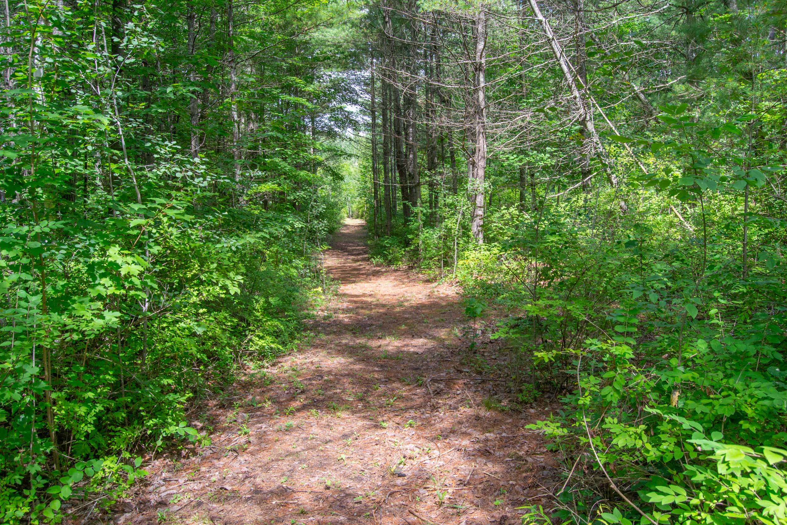
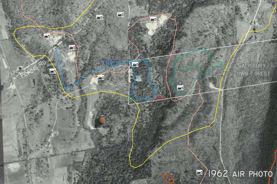
This year, the Salisbury Conservation Commission created a new trail in the Town Forest. This project started with a professional survey of the boundaries of the 140 acre town property which marked a little-known, half mile long, 30 foot-wide access corridor from Plains Road to the property. This now allows easy access to the western part of the town forest which few people in town had ever visited. Parts of the corridor were overgrown with invasive shrubs (honeysuckle) and a tremendous amount of labor was required to turn this corridor and the rest of the route into a hiking trail. With a small parking area on Plains Road it is now easy to visit the western end of the town forest.
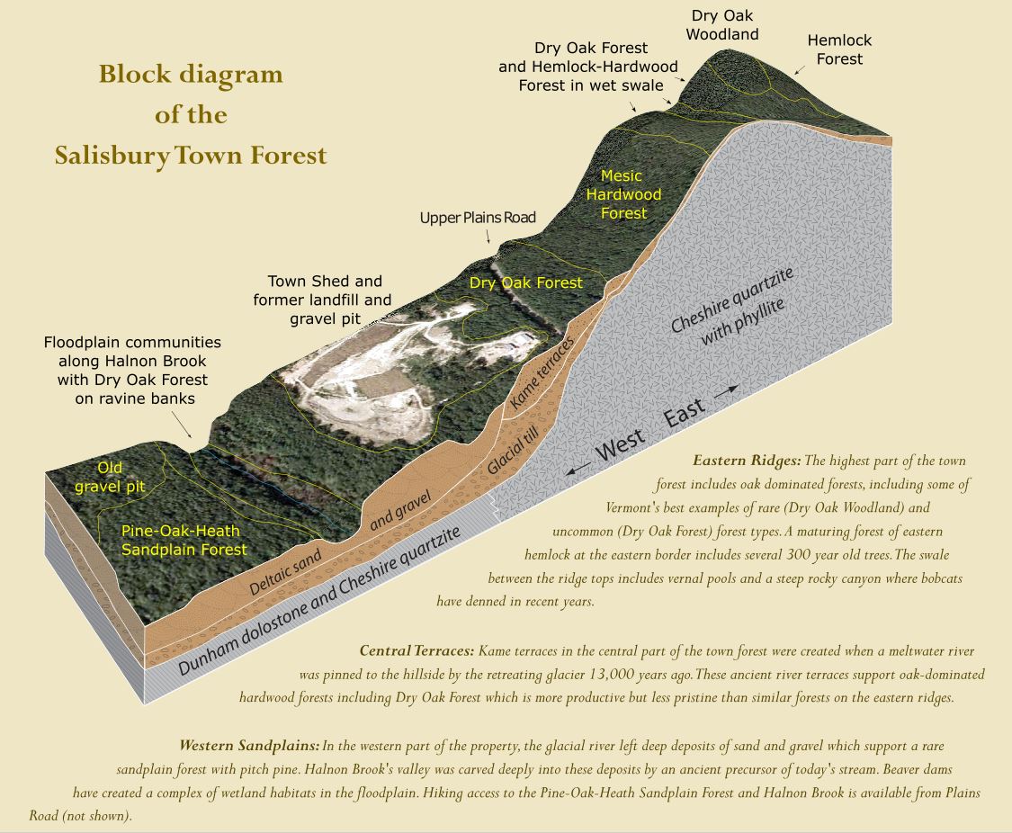
The western part of the town forest is unlike any other part of the property because it includes an undisturbed area of ancient pro-glacial delta. Dozens of feet of sand were deposited in a broad plain about 14,000 year ago when a huge glacial river met the huge glacial lake (Lake Vermont) that filled the Champlain Valley. This part of the property is also unique because the forest growing on the sandy delta is one of the rarest in Vermont. The most distinguishing feature of the forest, other than the delta it grows on, is the presence of pitch pine (Pinus rigida). Sandplain forests with pitch pine are rare in Vermont, and this newly discovered little parcel of “Pine-Oak-Heath Sandplain Forest” has attracted botanists and ecologists from all over the state to see it.
Not much is known about the history of this forest or how natural it is. There are aerial photos of Addison County from 1942, 1962, and 1995, and these offer some clues about past disturbances. Combined with information about the site’s glacial history, and local anecdotes about the area, we can piece together likely explanations for why this forest is here and why it looks the way it does today.

The pitch pine forest is at the leading edge of the pro-glacial delta where it is deepest (probably about 100 feet deep). The forest is surrounded by 10 sand and gravel quarries (see icons in figures) which were active sometime since 1942 (see figures below). These quarries exploit the deepest sand deposits and occur only on the delta. (Ploof’s sand and gravel pit at bottom center in Figure 4 is in an area of “Stetson gravelly fine sandy loam.” The gravel suggests that this quarry is in a collapsed kame terrace.)
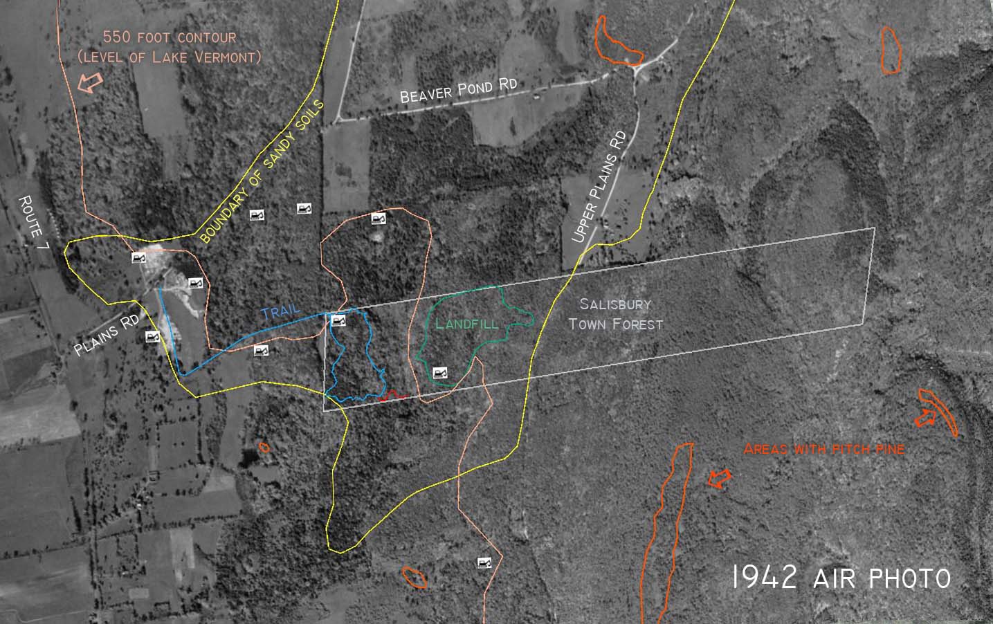
The 1942 photo (Figure 5) includes three active areas of sand extraction near Plains Road and possibly the beginnings of one other sand pit. The clearing at the western border of the town forest does not appear to be a sand pit — it is smooth and gray, not textured and white. It looks more like an agricultural field. This could be the field that was rented to a farmer early in the 20th century to grow potatoes and melons. I was told about this farmer by Martha Sullivan whose family has lived on the property adjacent to the western border of the town forest since before most of the trees in that forest even thought about germinating.
Except for this putative potato field, the continuous forest canopy in the 1942 town forest does not suggest any recent disturbance. Selective logging had probably happened throughout the forest, but no recent clear cuts or agricultural clearing is indicated. In 1942, the area of today’s pitch pine forest included a mix of deciduous and coniferous trees, and the coarse texture of the canopy suggests that the trees were large — not recently established saplings.
Between the 1942 and 1962 photos, the pitch pine forest was disturbed by the 1950 Thanksgiving storm. Martha Sullivan, who was born in 1939, told me that she played in the pitch pine forest when she was a child. She said that the 1950 storm blew down so many pines than she never played in that area again. Comparing the 1942 and 1962 photos, there were substantially fewer conifers in 1962 which is consistent with Martha’s account.
The time between the 1942 and 1962 photos was tough in other ways for the town forest. A clever con man sold the whole property illegally and it eventually was sold to Fred Johnson (of the A. Johnson Company) who quickly removed lots of timber. The town recovered the damaged property in 1957 through court action. Salisbury designated the property as a town forest in 1958 during a statewide effort to promote town forests. According to a 1993 report by David Brynn, in 1959 the timber on 40 acres directly west of Upper Plains Road was sold, although there is no evidence of logging roads or recent disturbance in the 1962 photo (maybe the trees were cut later). I wonder if it was easier to make the decision to sacrifice 20 acres for the landfill after all the big trees had been removed.

The clearings near the western border of the town forest are barely if at all discernible in the 1995 air photo (Figure 7) suggesting that the fields had not been cultivated for a couple of decades.
By 1995, discontinuous shrub and tree cover in the sand pit (at the NW corner of the property) indicates that the entire lifetime of that pit was between 1962 and 1995. The access corridor followed by the new Pitch Pine Trail was purchased by the town in October 1962 to truck sand and gravel from the pit. The landfill and gravel pit on Upper Plains Road were in full operation in the 1970s and the sand pit near the pitch pines was abandoned then. I think there are also 1974 and 1981 air photos which could pin down this timing.
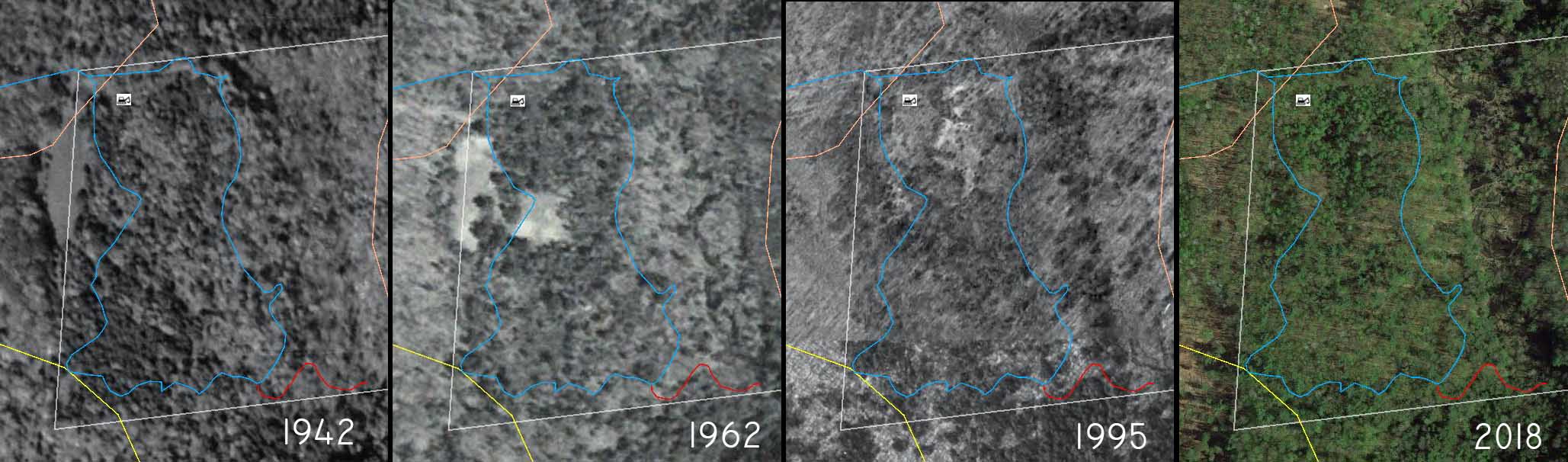
The series of air photos suggest that today’s pitch pine forest has had continuous canopy cover since well before 1942. The trees look large in 1942, so we can add several decades and conclude that a forest has grown there continuously for at least 120 to 140 years. This conclusion excludes the sand pit and farm fields near the pitch pine stand.
Logging has been done throughout the town forest for two centuries, but most of the property that is now forested has probably been forested for that entire time, that is, it has never been cleared for agriculture. This might also be true of the pitch pine stand but we can’t be sure. There are probably few if any trees in the stand older than about 100 years. The young tree ages are due either to regular timber harvest or because the stand developed from an abandoned agricultural field in the late 19th century (too early for air photos to record the event).
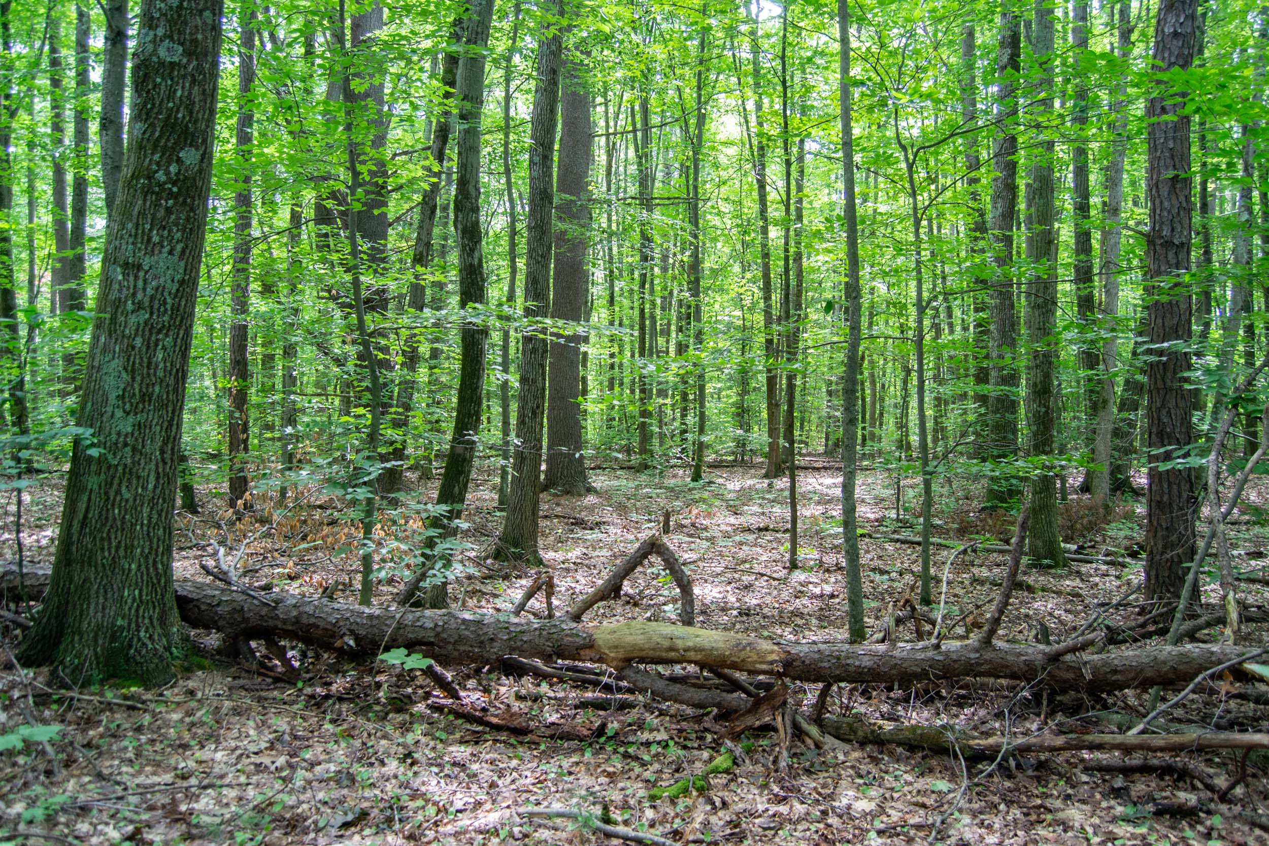
My observation that the forest floor in the stand was too flat for an old forest (Figure 2) suggested that the forest might have grown up in an abandoned agricultural field. That might be true, but the field would have had to be abandoned before 1900. The loose sandy soil might not form persistent tip-up mounds, so pit and mound topography could be subtle in this stand even when it is old. It might be possible to find evidence in the soil for past plowing. A “plow horizon” about six inches deep sometimes persists and can be detected in soil pits. Soil pits in the area of the 1942 clearing could be compared with pits where the forest canopy has been intact since before 1942.
There appear to be more coniferous trees in 1942 than in 1962 or any subsequent year (Figure 8). This is consistent with both the anecdotal blowdown of pines in 1950 and the continuing decline in health and numbers of pitch pines in the stand (which includes many recently fallen, standing dead, and almost dead pitch pines). Pitch pines do not live very long or establish well from seeds under a forest canopy so a slow decline is expected without repeated disturbances (e.g., wildfire) to encourage new tree establishment.
This stand differs from other pitch pine sandplains in Vermont in lacking most of the uncommon herb and shrub species present elsewhere (Figure 9). This could be evidence that this stand is too young to have developed the full flora or that it has gone too long since wildfire has encouraged regeneration of understory species. This suite of uncommon plants is a critical part of the definition of this sandplain forest type which otherwise is just a Dry Oak Forest with a few pitch pines on sandy soil (if there were not three dozen pitch pines in this stand, it would not have been distinguished from the thousands of acres of Dry Oak Forest nearby). On the other hand, these uncommon understory species are becoming rarer even in the large stands of this forest type in Colchester as the habitat shrinks due to development and degrades in the absence of recurring wildfires. Maybe our sandplain forest should not be disqualified because of a few missing rare plants.
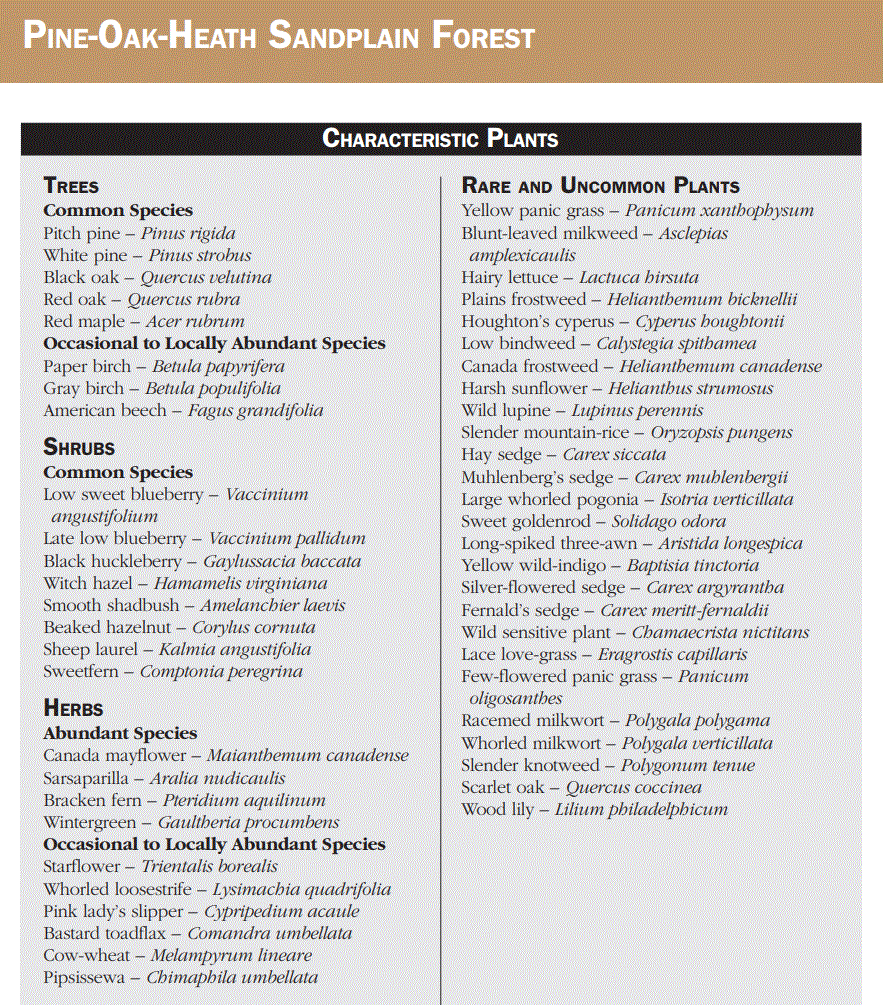
And maybe some of those rare species are present here and the botanists visiting Salisbury just missed them or visited at the wrong time of year to see them. We owe it to our little sandplain forest to fully describe its flora and maybe add a few rare plants to its species list. I have a T-shirt for anyone who finds 12 of the species on any of the lists in Figure 9 or just one of the species on the “Rare and Uncommon” list. Two T-shirts if your rare or uncommon species is confirmed at iNaturalist.
Hi there! I am having trouble locating this trail, I live in Leicester so it should not be this hard! ha ha Any tips????
Hi Christine, Sorry you missed the trail. The little parking area for the trail is on the steep hill on Plains Road directly east of Rt 7. There is some new post and rail fence bordering the parking area on the south side of the road.
Chris
Hi Chris,
I’m new to the area and interested in learning the local plants.
It sounds like the Pitch Pine flora has been surveyed is there an inventory available!
Thanks!
Flora of the local Pitch Pine trail, that is.
Thanks!
Hi Kirk,
Sorry for the delay. There is a plant list for the entire Salisbury Town Forest. It was made in 2013 by Marc Lapin and is part of the Management Plan for Salisbury Town Forest. I don’t know of a digital copy of the report but we could track one down if you are interested. The Salisbury Conservation Commission probably has a digital copy.
Chris