Three decades ago I started monitoring vegetation change in Glacier Bay National Park where glaciers have been retreating and exposing new land to colonization by plants. Each of the 10 sites I study was exposed at a different date over the last 250 years and it’s important to know that date for each site. It seems even more important now that I have so much data from the sites.
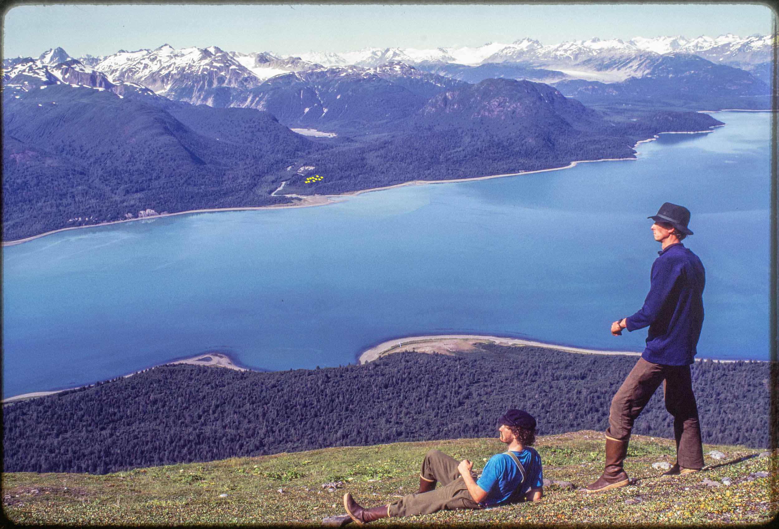
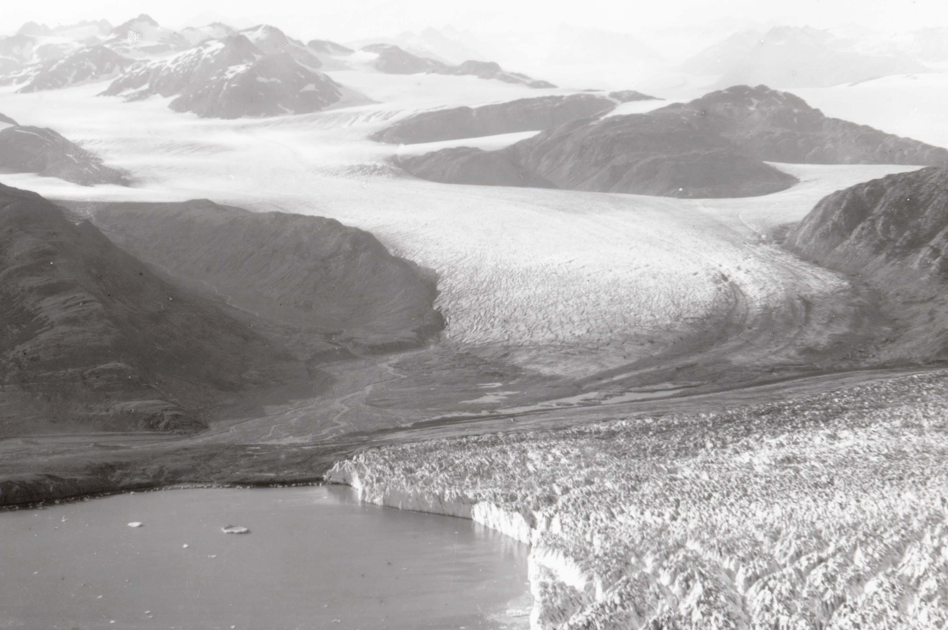
Figure 1. The view of Muir Inlet from 2000 feet above Muir Point on the shoulder of Mount Wright. Across the inlet are 10 tiny yellow squares where the Morse Creek study site is. We established those study plots near Morse Creek in 1988 without knowing exactly when the glacial ice had melted away there. Foreground: Left; H. Lentfer, Right; author. Kodachrome slide, August 1988.
Five of the 10 study sites were still under ice when John Muir first visited Glacier Bay in 1879. So maps and photos made by Muir and those who worked with him or after him provide the best clues to the age of my younger sites.
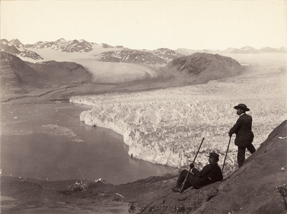
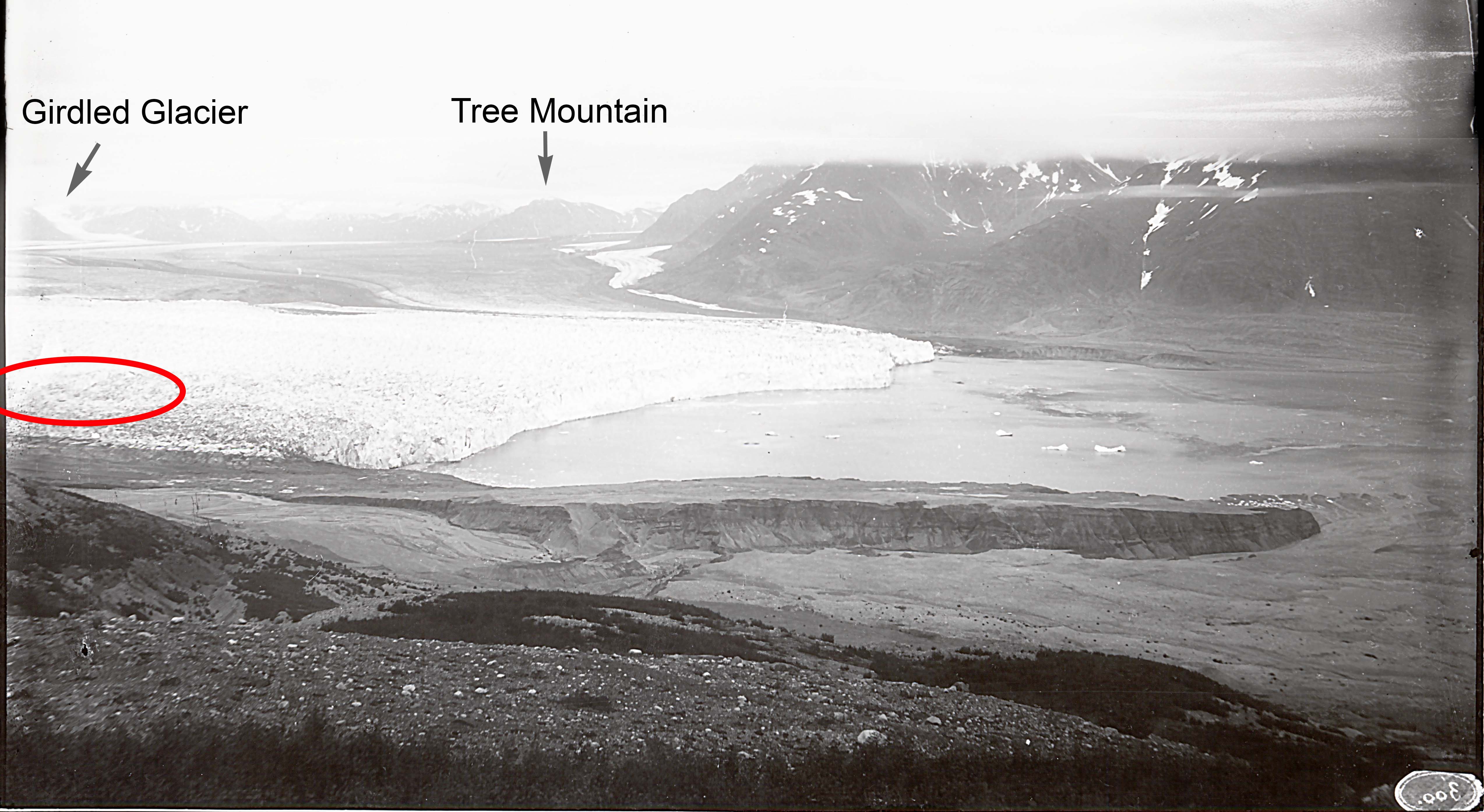
Figure 2. The view of Muir Inlet from 1800 feet above Muir Point on the shoulder of Mount Wright in 1893 when Muir Glacier filled most of Muir Inlet. We were very lucky that Frank LaRoche (right) had made a photo that is so similar to our 1988 color slide. Our photo was taken from a couple hundred feet higher on the hill because shrubs blocked the view from LaRoche’s perch.
For old photos to be helpful, they must be well-dated. The great photo by Frank LaRoche (Figure 2) is probably from 1893. The photo is somewhat ambiguous about whether the site of the Morse Creek study plots is still under the ice.
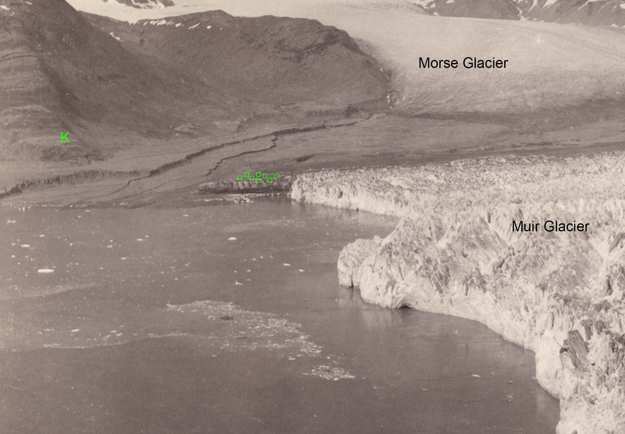
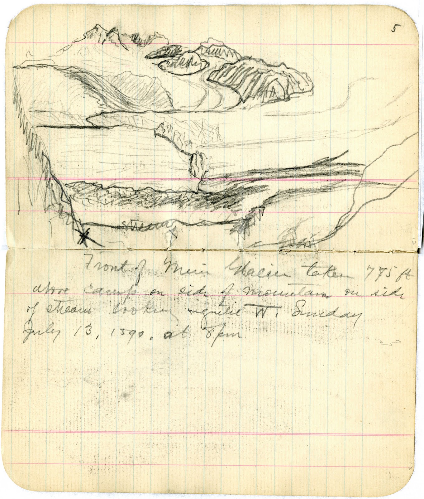
Figure 3. Crop of the Frank LaRoche photo in Figure 2 with the approximate location of the Morse Creek study plots (green squares). The landforms change fast as the glacier retreats so it is difficult to locate the plots accurately. The K (left) is the location of a survey station used by Harry Fielding Reid in 1890 and 1892 to measure the movement of Muir Glacier and map its terminus. Figure 4. Pencil sketch by Harry Fielding Reid of the terminus of Muir Glacier from the slope above Muir Point. Reid used a barometer to determine that he was at an elevation of 775 feet above John Muir’s camp which was near the beach where Muir was building his cabin. The view from this lower elevation suggests that Morse Glacier and Muir Glacier are still connected and my Morse Creek study plots are still under ice. But it is not very good data. Reid’s caption: “Front of Muir Glacier taken 775 ft above camp on side of mountain on side of stream looking magnetic W. Sunday July 13, 1890, at 8 PM”
Harry Fielding Reid was camping at Muir Point with John Muir in 1890 and making observations and measurements of glaciers for most of the summer. He probably took fewer photos than he had intended because “I unfortunately left the lens of my camera at home,” but J. F. Morse “rigged up one of his lenses, (just like mine) to fit my camera; he has also fitted up a box as a dark room, so I think we shall be able to get some good photographs and develop them here.” (Reid’s journals)
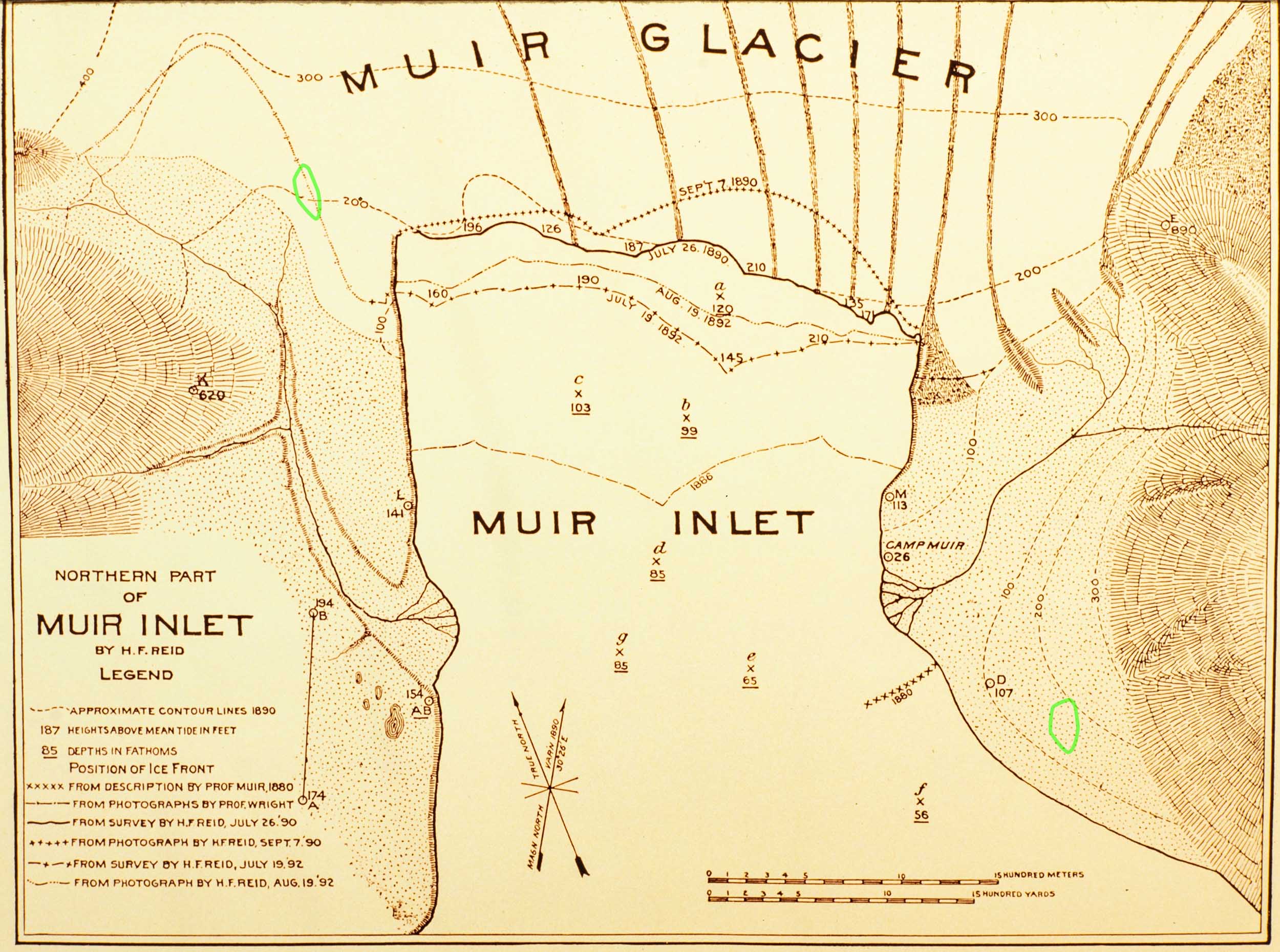
The National Snow & Ice Data Center (NSIDC) in Boulder has a large online collection of photos of glaciers including about 35 taken by Reid in Muir Inlet in 1890 and 1892. I was disappointed not to find the perfect photos of the Morse Creek study site taken from Station K (see Figures 3 and 7), but a few others were helpful.
Figure 5. Tidewater terminus of Muir Glacier (foreground) and grounded terminus of Morse Glacier (center) in 1892 from Harry Fielding Reid’s Station V high on Mount Wright. The photo is a year earlier and the photo station is possibly hundreds of feet higher and thousands of feet south of LaRoche’s perch. Morse Creek flows from Morse Glacier into Muir Inlet out of frame to the left. The following year (see the 1893 LaRoche photo) Morse Creek carved a new channel and met Muir Inlet close to left-most extent of Muir Glacier above. NSIDC Digital File ID: muir1892_382.Figure 6. The terminus of Muir Glacier photographed by H. F. Reid in 1892 from south of Station K (see Figures 3 and 7). The Morse Creek study plots are probably at the left margin of the photo and still under ice (red ellipse). Station K is on the hill at left between the camera and red ellipse. The shrubs in the far foreground are probably alder and would have been a source of seeds for the Morse Creek plots which have had an important component of alder for 100 years. NSIDC Digital File ID: muir1892_300Figure 7. Harry Fielding Reid’s map of the terminus of Muir Glacier made from his observations in 1890 and 1892 and observations of others. The approximate location of the Morse Creek study plots (green polygon, upper left) is at the labeled 1890/1892 margin of glacial ice. A nearby ice margin is not dated so the map is a bit ambiguous, but it suggests that the Morse Creek plots were probably not free of ice until after 1892.
My working date of 1895 for the Morse Creek plots is probably a good one although it could be a little early.
The glacier terminus position for 1880 (Figure 7, “from description by Prof. Muir”) suggests that my study site at Muir Point (Figure 7, green polygon, lower right) was probably ice free by 1880 if not earlier. My working date of 1883 for that site might be a little late.
The 1886 glacier terminus on Reid’s map is based on “photographs by Prof. Wright.” Wright’s camera must have been one of the first in Glacier Bay, and there are definitely no photos of my four older sites emerging from the ice (the daguerreotype was just being announced in France as the next older site was being exposed by ice retreat). The older sites have been dated using hundreds of tree ages determined by counting rings in tree cores of spruce. Those ages tell us when the trees started growing but not when the ice went away. That lag of a decade or two has to be estimated and we have to live with the unknown error.
4 thoughts on “Dating retreat”
Chris – this is a very good piece of investigative work that seems about as comprehensive as can be, pending the discovery of additional dated photographs/sketches, which is always possible but seems unlikely. I think, when putting all the available pieces together, you’ve pegged the dates; indeed, you did a remarkable job pegging them decades ago. As we know, ice-edge and near-ice-edge environments are chaotically rugose, and the variety of microsite discontinuities in surface topography and aspect surely contribute to a broad range of fine-scale conditions dictating ice melting in such a way that dating the exact time of exposure across the entire footprint of a 10-plot site (say, on the spatial scale of a few hundred meters on low-angle topography) is an exercise of some futility. I think +/- 5 y is as accurate as it’s going to get. Great job. -Lewis
It seems like a reasonable conclusion that the Morse Creek plots were under a solid mass of ice in 1892. It looks like the ice could be five or 10 or more meters thick. Five meters of ice might take longer than five years to melt away. So 1900 is probably a better ice-free date than 1895 for those plots.
Just think about how close seed-bearing alders would be to those plots in 1900. There were also one or two spruce seedlings in each plot before 1920. Eighty percent of the spruce in those plots grew slowly until about 1960 when they emerged above the alders. We don’t know how many spruce never escaped the alders. The surviving spruce have it made. Until the dastardly hemlock intervenes (In 2019 each study plot had 4 hemlock seedlings. Enjoy it while you can, spruce).

Chris – this is a very good piece of investigative work that seems about as comprehensive as can be, pending the discovery of additional dated photographs/sketches, which is always possible but seems unlikely. I think, when putting all the available pieces together, you’ve pegged the dates; indeed, you did a remarkable job pegging them decades ago. As we know, ice-edge and near-ice-edge environments are chaotically rugose, and the variety of microsite discontinuities in surface topography and aspect surely contribute to a broad range of fine-scale conditions dictating ice melting in such a way that dating the exact time of exposure across the entire footprint of a 10-plot site (say, on the spatial scale of a few hundred meters on low-angle topography) is an exercise of some futility. I think +/- 5 y is as accurate as it’s going to get. Great job. -Lewis
So are you thinking to amend your working “ice-free” date for the Morse plots to 1900?
It seems like a reasonable conclusion that the Morse Creek plots were under a solid mass of ice in 1892. It looks like the ice could be five or 10 or more meters thick. Five meters of ice might take longer than five years to melt away. So 1900 is probably a better ice-free date than 1895 for those plots.
Just think about how close seed-bearing alders would be to those plots in 1900. There were also one or two spruce seedlings in each plot before 1920. Eighty percent of the spruce in those plots grew slowly until about 1960 when they emerged above the alders. We don’t know how many spruce never escaped the alders. The surviving spruce have it made. Until the dastardly hemlock intervenes (In 2019 each study plot had 4 hemlock seedlings. Enjoy it while you can, spruce).
Indeed. The Tsugas are coming for you. But it’s gon’ be awhile, still.