Update (March, 2015): The KAPtery has moved to kaptery.com.
Thanks
At the end, I am at home in the woods

Update (March, 2015): The KAPtery has moved to kaptery.com.
Thanks
This Google Earth embed did not work well with all browsers so I was testing it here. You can learn more about this project here.
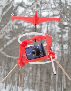
It took a couple of weeks for Jeffrey Warren’s message to sink in. At first I thought his workshop on balloon aerial photography at the Fine gigapixel conference in November promoted a fringe pursuit – lofting cameras on tethered helium balloons to make better maps than were currently available. But this pursuit emerged from the elegant convergence of modern camera technology and traditional lofting methods (balloons and kites). It was now possible for anyone to make good, current “maps” from stitched, low-elevation vertical photographs. Jeffrey is committed to inventing workarounds to the technological and financial obstacles that would otherwise put this process out of reach of the communities that might benefit from good maps. This was the focus of his thesis at MIT, and he has had great success bringing communities together around these new map images and the experience of making them. He has made the objective so compelling, and the process so simple and inexpensive that I soon realized I had to try it. Continue reading “My Flying GigaPan”