
 Today the KAPtery moved to its own site: KAPtery.com. This frees up my personal site (fastie.net) for other things, but most importantly offers you a much better place to learn about 3D printed camera rigs for aerial photography. The commerce part of The KAPtery should also work better — buying kits and parts should be easier and more secure. Continue reading “The KAPtery has moved”
Category: KAP
Titan 2 launch

I almost didn’t make it to the farm yesterday because 1) one of my A590s died, 2) the old CHDK sync mode does not work with A590s, and 3) it took me a while to install and learn how to use the new CHDK. Teddy almost didn’t make it because I was not sufficiently explicit about which gate I meant and he waited at the other gate. But we were flying the Sutton Flowform 16 by 5:00 PM in a janky 15 mph north wind with gusts of 20 mph. The Titan 2 Rig made its maiden flight with two A590s triggered by an MK111 timer.

One of the A590s was full spectrum (its IR block filter had been removed), and it had a 720 nm IR filter in front of the lens. So that camera saw mostly near infrared light. I white balanced that camera on grass, and the photos have a little color in them. We took 565 pairs of visible/infrared pairs over the Middlebury College Organic Farm. The cameras were aimed straight down, but the wind was swinging the Picavet quite a bit, so we got lots of slightly oblique photos, and more than 100 of the pairs were before or after the flight part of the flight. The shutter speed on both cameras was locked at 1/800 second at ISO 80, and most of the photos were taken at f 2.8. Some of the NIR photos were taken at f 2.6 (the max aperture), but there was not much difference in exposure between the two cameras. About 80% of the photos have no conspicuous motion blur. Continue reading “Titan 2 launch”
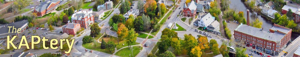
The KAPtery is open

Update (March, 2015): The KAPtery has moved to kaptery.com.
Thanks
Kite’s eye view
 In the late nineteenth century, hand drawn “bird’s-eye maps” were a revelation to earthly New Englanders. When exotic hot air balloons were the only way to gain such a perspective, enterprising artists just imagined what a bird might see. The customers for these maps lived and worked in the buildings depicted, so these are probably placed with some accuracy, relying on existing maps for data. It is the details of the rest of the landscape that were recorded nowhere else. In the 1889 drawing below, cleared fields, orchards, and shrubby growth nearly to the top of Hogback Mountain confirm the wisdom that in 1850 the entire slope, like others all over Vermont, was probably cleared of trees. Today, the young ages of the trees tell the same story, but an old bird’s-eye view is still a revelation. Continue reading “Kite’s eye view”
Grave images

Practice

Over Middlebury

Last month I went to the Middlebury Farmers’ Market at Marble Works for the first time ever. My garden had been suffering some scurrilous blight and I was about to feed 10 people for the LEAFFEST weekend. I looked along the row of vendors to the steeple of the Congregational Church beyond some trees and realized there might be enough space to launch a kite there. A west wind would take the kite the length of the lawn and then over toward the church on the “Green,” the village commons. This could offer a unique view of the village center. But the wind almost never blows from the west here due to the north-south trend of the Champlain Valley. Other wind directions would make the flight less rewarding and the launch and landing more risky, and I had never flown a kite from such a small area surrounded by so many power lines, buildings, trees, river banks, and busy roads, so I assumed I would never fly there. Continue reading “Over Middlebury”
Downlink

Twice this year I walked around for more than an hour flying a kite-lofted camera that I thought was taking photos, when in fact it was just fooling me into getting exercise. On the first occasion the shutter controller battery died, and the other time the camera just got confused and stopped shooting. I think I sent radio commands to shoot too frequently and it decided to take a nap. This happened another time as well but I happened to reel everything down after only 20 minutes of not taking photos while I was jogging here and there. I have modified the controller so the battery lasts much longer, and I have learned to be patient when sending radio commands, but I am certain that the rather fragile KAP rig electronics will surprise me again with their unexpected inactivity. So I have been looking for a way to monitor the camera operation from the ground. I have been brainstorming with some friends about how to do this, and Don Blair, a physics graduate student at UMass has been prototyping an alert system based on a $20 pair of walkie-talkies. I couldn’t stand hearing about all the fun he was having in Amherst using MOSFETs to remotely push the walkie-talkie PTT button, so I decided to build my own solution. Continue reading “Downlink”
Sprucing up the hills


I was able to get some aerial photos of most of the plots after I had marked each seedling with pink flagging. I flew a dual camera KAP rig with normal and infrared-modified cameras lofted by a kite. I will be experimenting with false color IR (NRG) and NDVI images which can be created with information from both cameras. Continue reading “Sprucing up the hills”
Chatanika Dredge

Swamp NDVI
On May 5 my infrared KAP rig made its first photographic flight. The shutters of two Powershot A495 cameras, one modified to record only near-infrared (NIR) light, were triggered every 10 seconds by an AuRiCo KAP controller. The Levitation delta kite hoisted the rig over the northern edge of the Salisbury Swamp, VT. In about 1.5 hours, 420 synchronous pairs of normal and NIR photos were captured. It has taken a while to process just a fraction of these images, but the results are promising. First, some kite porn:
Unexpected Panorama
