The north end of Lake Dunmore is surrounded by 250 acres of flat, level land which is less than 25 feet higher than the lake. The soil is gravely sand, and lobes of sandy soil bulge into the lake at the Keewaydin and Songadeewin summer camps. I assumed these sandy lobes were deltas built into the lake as the Laurentide glacier melted away to the north, but now I’m not so sure.
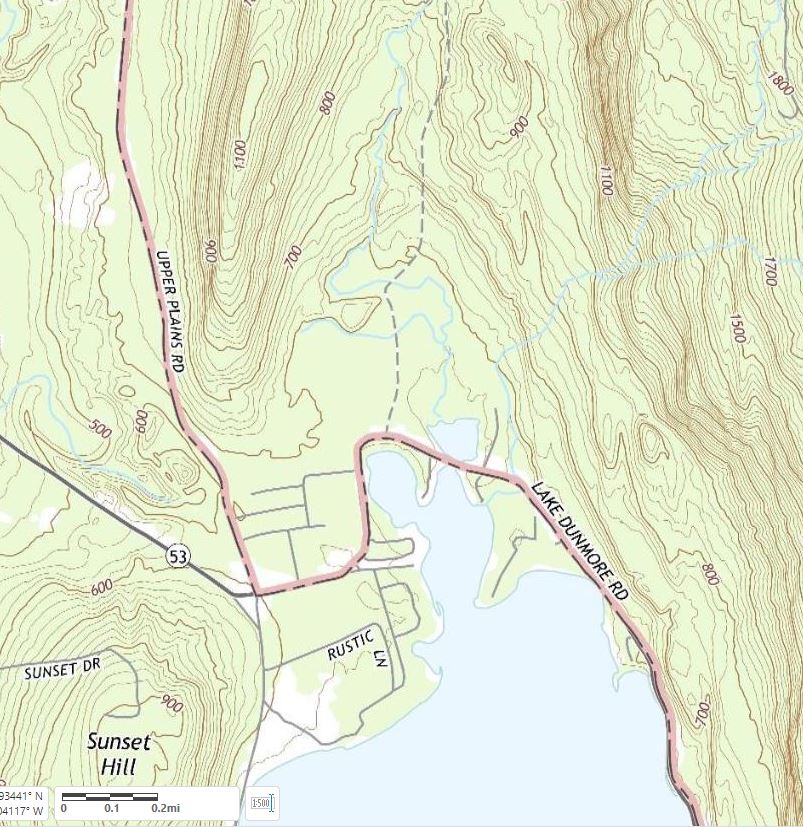
Figure 1. When I moved to this area 25 years ago this was the best map available for interpreting the history of this landscape. From this map we know that it is flat near the lakeshore north of Lake Dunmore. From the soil map we know that this flat area is gravelly sand. Learning anything else required using your legs to walk around. Camp Songadeewin is the southernmost flat area on the western side of the lake, and Camp Keewaydin is the flat peninsula on the east side. Part of USGS East Middlebury quadrangle.
Note: click or tap the images to enlarge them.
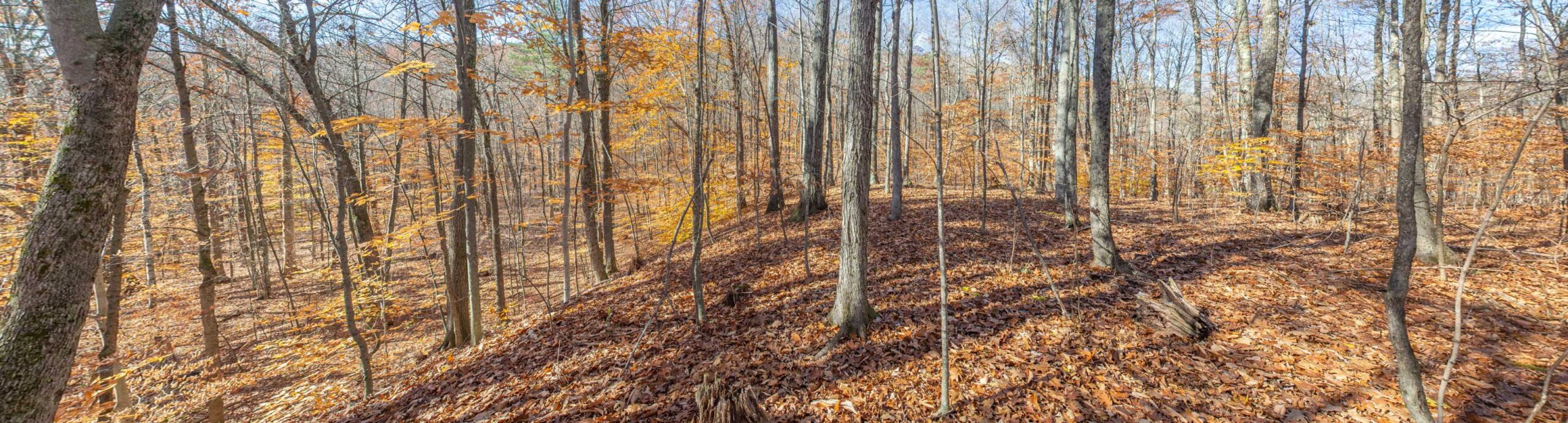
The lake margins are not the only features near the lake that are gravelly, sandy, and flat. Elongated terraces cling to the sides of the slopes above the lake. The terraces are 100 to 400 feet above the lake and their arrangement and gentle slope toward the south indicate that they are river terraces. The hillside served as the eastern bank of the river and in most cases glacial ice was the western bank. There is no other way to explain these high, dry, hanging terraces. These perched river beds were built in contact with glacial ice 14,000 years ago and are classic examples of kame terraces. Some of the lower terraces could have been formed by rivers after ice was gone from the area.
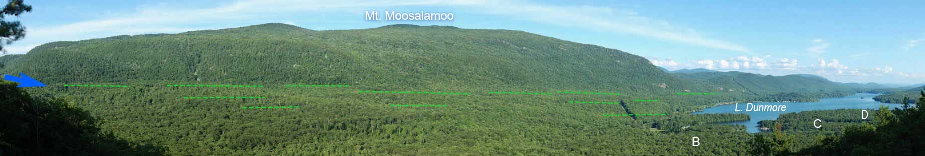
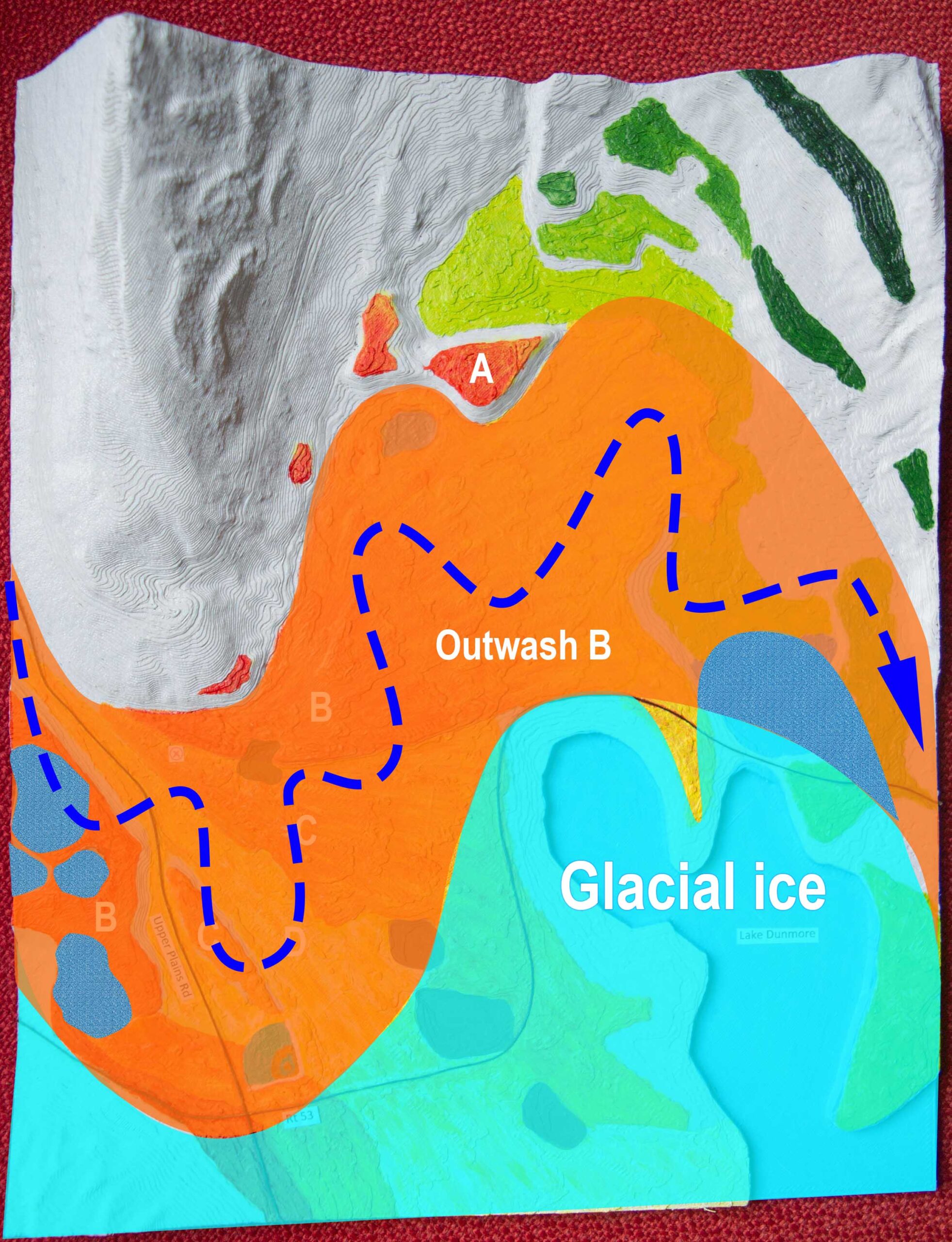
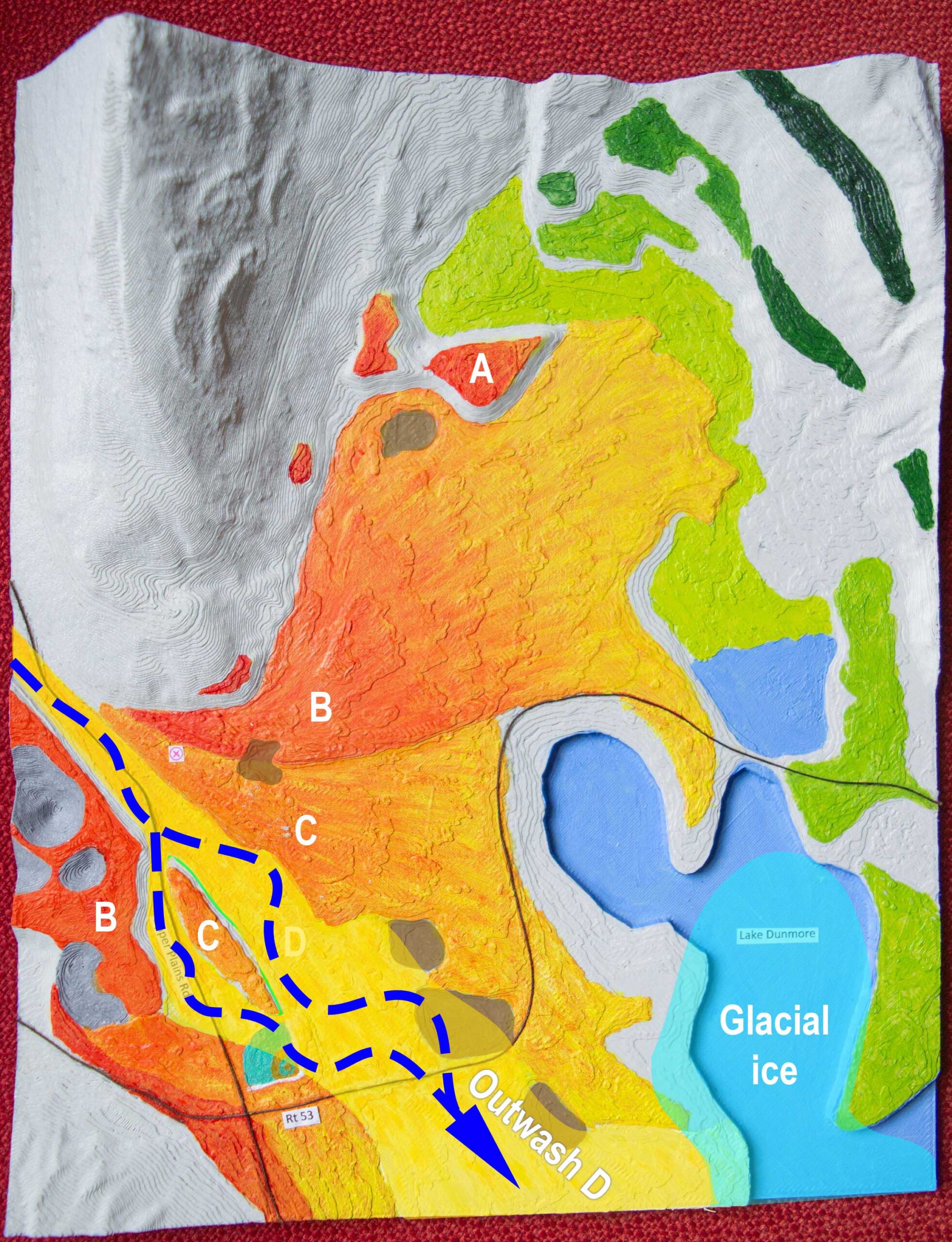
Figure 2. The north end of Lake Dunmore from 450 feet above the lake on Burnt Ridge. Dashed green lines are the locations of river terraces to the north and east of the lake. The rivers that built these terraces 14,000 years ago flowed in from the north (blue arrow). While all or most of these terraces were being formed, everything below the green lines was covered with glacial ice. The letters are the locations of three outwash surfaces (see Figures 7 and 9). This panorama was stitched from more than 600 telephoto photos taken on July 10, 2009. The full resolution image can be seen here: http://www.gigapan.com/gigapans/28944. At that site, if you zoom in far enough, the names of some mountain peaks are revealed.Figure 2.5. Photo of hand-painted 3D-printed model of LiDAR bare earth surface. Area includes the Green Mountain Escarpment (eastern edge of the Champlain Valley) between East Middlebury (top) and Lake Dunmore (blue, bottom). When the eastern edge of the waning glacial ice had melted down to about 1000 feet above sea level, rivers flowed south at that elevation (dashed orange line) in the “valley” between the hill and the ice (these rivers made the kame terraces marked in Figure 2) . When the ice had melted to a lower elevation, rivers flowed along the current path of Upper Plains Road at about 700 feet above sea level (dashed green line). Later, water coming out of the watershed of the current Middlebury River flowed into Glacial Lake Vermont (elevation 550 feet) at East Middlebury and built a delta that grew almost as far south as Lake Dunmore (dashed blue line). The earlier two river courses (orange and green) brought water-borne sediment to the north end of Lake Dunmore for maybe a decade or two 14,000 years ago. Dark brown: flattish terraces assumed to be river beds. Light brown: collapsed terraces. Yellow and gold: outwash surfaces and/or deltas. Peach: fine sand and silt presumed to be deltaic foreset beds. Light blue: clayey lake bottom sediments. Red: sand and gravel quarries. Vertical length of the map represents 4.25 miles.
As the southern front of the Laurentide glacier melted north in the nearby Champlain Valley, a lot of water flowed into the Lake Dunmore basin. For maybe a decade (or two?) it flowed from between the bedrock ridges north of the lake (Figure 3). Later, when the shrinking glacier made way for rivers along Upper Plains Road, water flowed into this basin from the west for maybe another decade or two (Figure 3). Kame terraces mark the different elevations of these rivers, and the broad, stony riverbeds that remain today indicate that these were raging rivers capable of carrying a huge sediment load.
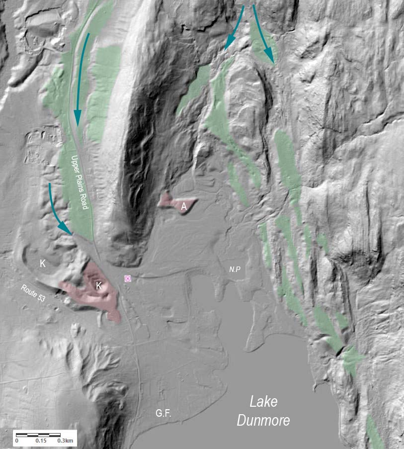
Figure 3. LiDAR hillshade topographic map of the north end of Lake Dunmore. The perched, stony, gravelly, and sandy terraces built by glacial meltwater rivers are green. Blue arrows are four different flow patterns of river water from the oldest (upper right) to the most recent (left). “A” is a remnant of a river terrace raised above the valley floor. “K”s are kettle holes in deep outwash deposits. N.P. is North Pond. G.F. is the location of the Vermont Glass Factory built in 1812. Data for this map are airplane-borne LiDAR available for viewing and download from The Vermont Center for Geographic Information and the Vermont Natural Resources Atlas.
A large amount of glacio-fluvial sediment (sand, gravel, cobbles, stones) was brought by these rivers. Some extant landforms suggest how much sediment was moving around in those decades. As water poured in from the west, it spread out and deposited wide outwash fans north of the lake. A 12 acre remnant of one outwash surface is 25 feet higher than the surrounding, younger, outwash surface (Figure 4, Surface A). Surface A might have originally covered a large area north of the lake but most of it was eroded away by subsequent rivers that formed surface B (Figure 4). These rivers delivered tons of sediment to this place and then carried away almost as much as they brought.
Figure 4. Closer view of the area in Figure 3. Surface A is a remnant of a river bed that was 25 feet higher than Surface B. Surface B is incised with braided channels suggesting a textbook outwash fan (Figure 5). These 14,000 year old anastomosing river channels are the best thing I have ever found in LiDAR data (and I have even found eskers!). Surface C is four to six feet lower than Surface B. Figure 6 is a photo taken at the camera icon. Three putative sand quarries are marked, some possibly associated with the early 19th century glass factory.
The rivers that moved sediment around 14,000 years ago were not like today’s rivers in Vermont. Surface B (Figure 4) is still scarred by the river channels that were active while the glacier was nearby. The rivers carried so much sediment from the glacier and the unvegetated landscape that channels would fill quickly and force the water to find new paths (Figure 5).
The eight figures below begin with a 3D printed model of LiDAR topographic data. The plastic model is hand painted to highlight the existing flat surfaces where glacial rivers deposited sandy/gravelly sediments 14,000 years ago. In subsequent figures, I used Photoshop to add the position and extent of the glacial ice margin that determined where the rivers could flow. I am guessing that this entire sequence of six stages took a decade or two. This sequence is hypothetical and based on interpretations of field observations (some of which were inspired by the LiDAR data).
Figure 9. The base map for the following six figures. In general, darker colored surfaces are older and higher. Surfaces B and C were bisected by later river flows and have matching terraces on either side of the newer, lower surface (these are not kame terraces, just river terraces). There is probably no matching terrace for Surface A because the rest of it was eroded away as Surface B was formed. The three small reddish terraces to the west and southwest of Surface A could be other remnants of the original Surface A. Brown areas are shallow depressions and are probably sand quarries. These are very old and have maturing forest growing across them (the upper two), or have been disturbed by human development (lower three). Some or all of these quarries could have been excavated as early as 1812 to supply sand for the Vermont Glass Factory (Figure 3). The sand was found to be unsuitable and instead sand was brought from Brandon (probably from the Forestdale delta). The vertical length of these maps represents about 0.9 miles.Figure 10. The first river bed created in this scene is recorded as a high kame terrace at 750 feet asl (upper right). The glacial ice is continuous with the Champlain lobe of the Laurentide Glacier which was hugging the western face of the Green Mountain Escarpment and diverting all runoff from the mountains into the “valley” between the bedrock hillside and the ice. The glacial ice would have been about 350 feet thick over Lake Dunmore. The river flowed south along the eastern side of Lake Dunmore until it reached the level of Lake Vermont where it was building a huge delta at present day Forestdale (six miles south so Lake Vermont was at a present elevation of about 525 feet asl there). A river following a higher and older kame terrace which is not included in this scene had already been contributing to the Forestdale delta for years.Figure 11. As the ice front in the Champlain Valley melted northward, the glacier also melted downwards and gradually exposed lower hillsides. This allowed ice-marginal rivers (e.g., blue arrow) to find new paths and build lower river beds. The lower series of kame terraces in this figure was occupied by a river some weeks or months after the scene in Figure 10. There were subsequent stages of terrace building along this bedrock hillside which I will skip here.Figure 12. When the thinning ice to the north allowed the meltwater to run along the route of Upper Plains Road (see Figures 2.5 and 3), the earlier river routes were abandoned forever and a long series of high kame terraces (all the way north to Route 125) is all that remains of them. At this stage, a similarly huge river flowed in from the western edge of this scene after following the extant kame terraces along Upper Plains Road. Only a few small remnants of the outwash fan built at this time remain in this scene (Surface A and its smaller red remnants) but it must have been an extensive outwash surface because it was built by a river draining the melting glacier to the north and west plus the ice-free mountain landscape to the north and east. Evidence that glacial ice still filled Lake Dunmore is Lake Dunmore itself. Months or years or decades of glacial rivers carrying sediment through this area would have filled the lake basin many times over. At this time the ice sitting in the lake basin was maybe 250 feet thick and still attached to the main Champlain lobe of the Laurentide Glacier. Figure 13. While the meltwater river bringing sediment to this scene was still running along the Upper Plains Road terraces, the river eroded away most of the earlier Outwash A surface and found a new, lower level. Today, the remnant Surface A retains the shape it assumed at this time. Anastomosing channels of a braided river are still evident in the Outwash B surface (Figure 4). Pieces of ice broken off from the glacier edge (blue-gray polygons) were buried by the new Outwash B deposits. The four ice masses at the left became kettles as that ice later melted. I am guessing that North Pond, a shallow northern extension of Lake Dunmore today, might have been protected from filling by some ice while the river flowed across it. Figure 14. Before reaching this scene, the river building the Outwash C surface ran along terraces that are no longer intact west of Upper Plains Road (see leftmost blue arrow in Figure 3). The incoming river channel is not connected to any extant upstream surfaces (maybe the water was coming out of the glacier or ice-marginal lake). The Outwash C river bisected the higher Outwash B surface which has extant remnants on both sides. The glacial ice filling Lake Dunmore is now separate from the Champlain ice lobe and water could have flowed south along both sides of the ice. On the western side (left), the river might have followed the current path of Lake Dunmore’s outlet into the Leicester River for at least a short time. At 550 feet asl, that river met Lake Vermont where today there is a 50 acre area of sandy, gravelly soil, the remnants of a delta. Kettles (dark gray) are forming in Surface B where ice was buried (it would have taken a few decades for all the buried ice to melt).Figure 15. In the last stage of this sequence, the river carved into the surface of Outwash C and formed a new, lower outwash surface (Surface D). The water was probably flowing south and still contributing to the growth of the Forestdale delta six miles away. Some ice was probably still present in Lake Dunmore preventing it from filling with sediment. Rivers could have run over this ice and covered it with sediment, so the existence of Lake Dunmore is dependent on a process not unlike kettle formation. Is Lake Dunmore just a really big kettle pond?Figure 16. This is Figure 9 again. The scene looks this way because of a series of geomorphic events maybe something like the one described above. A mile-long walk in this scene can take you to many 14,000 year-old clues to these events including kame terraces, outwash fans, scarps between outwash levels, channels carved into outwash fans, kettle holes, and gravelly sandy soils.
When the Champlain lobe of the continental glacier melted away from the hillside where today’s Middlebury River meets East Middlebury (a few miles north of Lake Dunmore), the proto-Middlebury river was able to flow directly into Lake Vermont for the first time (Figure 2.5). Meltwater from the glacier was no longer shunted south along the hillsides south of East Middlebury. That was the end of big rivers flowing into the Lake Dunmore basin.
When the stagnant glacial ice in Lake Dunmore finally melted away, the lake was more than 100 feet deep and it is still that deep today. Maybe the sandy shoreline lobes at Camp Keewaydin and Camp Songadeewin are small deltas built after ice-melt had opened the edges of the lake, and rivers (especially C and D) were moving their last loads of sediment. That would have been a final gasp of deposition before the north Dunmore outwash fans were abandoned forever. Otherwise Lake Dunmore might have filled in and become just another flat place along Upper Plains Road.
3 thoughts on “The flats and scarps of Lake Dunmore”
Maybe it’s just me, but the phrase “final gasp of deposition” suggests certain contemporary legal/political images. No matter, I applaud your detective work here – very cool.
Yes, but thawing political tensions won’t stop the erosion of faith till our sedimental favorites go down that rocky road. Another fine kettle of fish, if you get my drift.
Wow! This stories just gets more and more interesting. Thank you, Chris, for putting the time into discovering it, illustrating it and explaining it. I want to read it again and again. I have been fascinated by this landscape since we first visited it together decades ago.