Fun Factivities: Daytime Darkness

In 1992, Kellogg’s was collaborating with World Book to deliver educational content to kids on cereal boxes. In addition to its popular encyclopedia (still in print and updated every year), World Book produced Childcraft, a 15-volume set about everything interesting to kids. Childcraft produced the cereal box content.
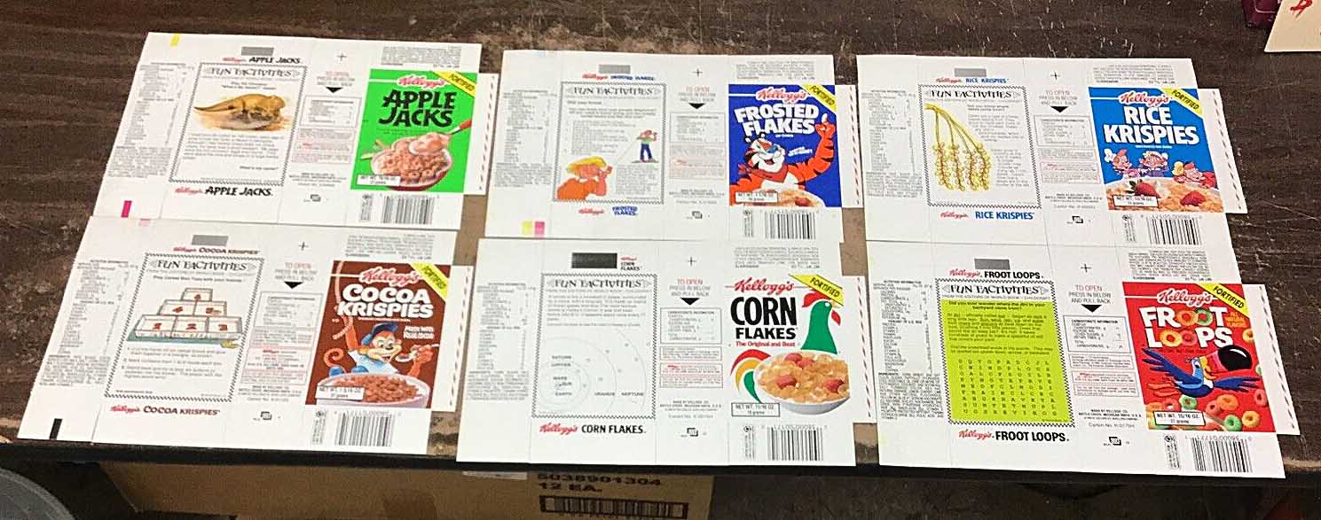
Figure 1. Six cereal boxes (ca. 1992) from a Kellogg’s Variety Pack. Each box has a World Book Childcraft “Fun `Factivity.'” These pristine boxes were for sale on eBay.
Continue reading “Fun Factivities: Daytime Darkness”

The flats and scarps of Lake Dunmore

The north end of Lake Dunmore is surrounded by 250 acres of flat, level land which is less than 25 feet higher than the lake. The soil is gravely sand, and lobes of sandy soil bulge into the lake at the Keewaydin and Songadeewin summer camps. I assumed these sandy lobes were deltas built into the lake as the Laurentide glacier melted away to the north, but now I’m not so sure.

Figure 1. When I moved to this area 25 years ago this was the best map available for interpreting the history of this landscape. From this map we know that it is flat around this part of Lake Dunmore. From the soil map we know that this flat area is gravelly sand. Learning anything else required walking around. Camp Songadeewin is the southernmost flat area on the western side of the lake, and Camp Keewaydin is the flat peninsula on the east side. Part of USGS East Middlebury quadrangle.
Continue reading “The flats and scarps of Lake Dunmore”

Bridgewater Hollow BioBlitz

This past Sunday, six people with smartphones and one guy with a pad of paper descended on a 350 acre property in the Green Mountains near Bridgewater Hollow, Vermont. The smartphone people used iNaturalist to document about 300 observations of plants and animals (and quite a few things that might be neither, like slime molds and fungi). The paper guy was Brett Engstrom whose list of vascular plants is probably longer than the list of all the species that everyone else compiled. 

Continue reading “Bridgewater Hollow BioBlitz”

Graft

Black Prince, a variety of Russian Krim tomato that I tried for the first time this year.
Black Prince, a variety of Russian Krim tomato that I tried for the first time this year. September 14.
I first heard about grafting tomato plants two years ago, but hot house tomato growers have been doing it for a while, and in other countries grafting has been an important way to increase vegetable production for decades. It was so important in Japan that a robotic grafting machine was developed in 1993. By grafting desirable tomato varieties onto selected rootstocks, generally increased vigor and also specific resistance to root-borne diseases is gained. My tomatoes have failed in two of of the last four years, so I decided to try grafting last year. Continue reading “Graft”

Kite’s eye view

In the late nineteenth century, hand drawn “bird’s-eye maps” were a revelation to earthly New Englanders. When exotic hot air balloons were the only way to gain such a perspective, enterprising artists just imagined what a bird might see. The customers for these maps lived and worked in the buildings depicted, so these are probably placed with some accuracy, relying on existing maps for data. It is the details of the rest of the landscape that were recorded nowhere else. In the 1889 drawing below, cleared fields, orchards, and shrubby growth nearly to the top of Hogback Mountain confirm the wisdom that in 1850 the entire slope, like others all over Vermont, was probably cleared of trees. Today, the young ages of the trees tell the same story, but an old bird’s-eye view is still a revelation. Continue reading “Kite’s eye view”

Grave images

Chopping hay below the Fled as I walk alongside.
Chopping hay below the Fled as I walk alongside. Click images to enlarge
My town’s cemetery committee would like to have maps of the grave stones in the three town cemeteries. The late Fletcher Brush cataloged the headstones in each cemetery in the 1990s, and probably made hand drawn maps, but it would be nice to have more official versions. I was asked on Thanksgiving about helping with this mapping, and the next day was beautiful AND had a nice south wind. Flying a kite over the cemetery in the village requires a south wind, and the row of overhanging locust trees along the edge makes late autumn the best season to image all the headstones from above. So I couldn’t resist exploiting what might be one of the last good opportunities to image this site for a long while. Continue reading “Grave images”

Practice

Self portrait
I have lost a kite, but I have never lost an RC transmitter (around neck). This was taken during one of the first short-lived launches.
The winds have been light this week as the peak colors have been waning and my KAP pack has been poised by the door. I finally had to ignore the “4 mph” reports at WeatherUnderground and WeatherSpark and just go. I went to the hay field south of the Salisbury village where the south wind might push the kite toward the village center. There were some gusty spells that lifted the KAP rig just high enough so that I had to frantically reel it in when calm returned. Attaching and detaching the Picavet in a hurry requires more practice than I have had, and I surpassed my own record for making nasty tangles that included Picavet line, kite line, and alfalfa. At one point I didn’t have time to take off the Picavet as I wildly pulled the line in hand-over-hand, laying it across the field. After untangling (not my favorite thing), I called it a day, disassembled the Fled, and headed back across the field to the pack. When I got there the wind had picked up, so I assembled the Fled, threw it into the air, and had the rig attached when I noticed that I had left the RC transmitter out in the field — out in the huge field of alfalfa and grass that is at places a foot taller than the transmitter (the thing around my neck in the photo above). Continue reading “Practice”

Over Middlebury

I flew the Levitation Delta for 20 minutes before I had the courage to attach the KAP rig.

Last month I went to the Middlebury Farmers’ Market at Marble Works for the first time ever. My garden had been suffering some scurrilous blight and I was about to feed 10 people for the LEAFFEST weekend. I looked along the row of vendors to the steeple of the Congregational Church beyond some trees and realized there might be enough space to launch a kite there. A west wind would take the kite the length of the lawn and then over toward the church on the “Green,” the village commons. This could offer a unique view of the village center. But the wind almost never blows from the west here due to the north-south trend of the Champlain Valley. Other wind directions would make the flight less rewarding and the launch and landing more risky, and I had never flown a kite from such a small area surrounded by so many power lines, buildings, trees, river banks, and busy roads, so I assumed I would never fly there. Continue reading “Over Middlebury”

Go Orioles!

A month ago, on May 10, I noticed a wad of dry grass in the birch tree outside my home office window. It was obvious what it was, and a noisy pair of Baltimore orioles soon confirmed that a nest was being constructed. Four days later the nest building seemed to be mostly completed, and I stopped taking photos (click them to enlarge).

Female Baltimore oriole weaving a nest in paper birch tree
May 11, 2012. Female Baltimore oriole weaving a nest in a paper birch tree
Continue reading “Go Orioles!”

Unexpected Panorama

KAP over the Kame terrace from Petri's field
Note the Henry's Handle hanging from the belt. The kite line is cleated to that while I attach the Picavet and run through the pre-launch checklist.
The huge kame terraces in my town support a dry-tolerant forest of oaks, beech, and red maple, and as the new leaves emerge it is easier to tell the species apart at a distance. So I have been hoping to fly a kite over the terraces in early May and see if the trees delineated the terraces. The wind was gusty today, but it was supposed to calm down a bit in the afternoon, so I hiked up the hill and launched the nine foot Levitation delta. It was after 6:00 PM when I first triggered the S95 with the Futaba transmitter, and the light was wonderful even if the wind was not. It mostly cooperated until it slowed down enough to send me running upwind barely fast enough to keep the line out of the trees. But I had 900 feet of line out for a while and the camera was well out of the clearing were it could see the tree tops as I never had. Continue reading “Unexpected Panorama”