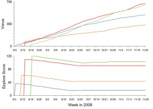
I have been collecting data about the gigapans I upload to gigapan.org ever since I noticed some unexplained behavior in the View counts and Explore Scores of my first public gigapans. Unlike YouTube, Gigapan does not make archival user data publicly available, so it has to be independently collected. Kilgore661 has been doing a great public service by collecting these data for all gigapans for about three years, and you can explore his archive here and use his nifty graphing tools. I have more than a year’s worth of slightly denser data on my own gigapans. Graphs of these data are wildly revealing about the nature of Explore Scores and the inherent differences among gigapans in how they accumulate Views. I hope to show some of these results at the Fine Outreach for Science Workshop in November.

Unlike Kilgore661, I wasn’t smart enough to use the gigapan API to automate this process, so I have been screen scraping and I just had to stop. The gigapan API is essentially undocumented, but thanks to Miriam at gigapan and Will at Fastie Systems, I now have a tool that collects the pertinent data on all of my gigapans and makes it easy to paste it into Excel. You can see the tool in action here, and learn how to install it on a Web page to fetch the information about your own gigapans.
Creepy and Cute
In Pittsburgh at the Fine International Conference on Gigapixel Imaging for Science in November, there will be a gallery show in the Carnegie Museum of Natural History of huge prints of eight gigapixel images. One of these will be a gigapan of my backyard patch of bergamot surrounded by an unnatural swarm of Ruby-throated Hummingbirds. You can see the gigapan here. The detail included below is about 4% of the area of the entire gigapan which will be printed about six feet wide.

Click the image to enlarge.
Gigapans in Google Earth KML tours
I have incorporated some gigapans into Google Earth KML tours and tried three ways to share the tours with others: embedding, KML preview, and downloading. There is not a clear winner. An earlier post has examples of all three methods.
A Google Earth KML (keyhole markup language) file can contain placemarks, paths, and polygons, but it can also include a tour in which recorded navigation movements (flying around) and an audio track can be played back. If a gigapan is included in a KML file which also includes a tour, the user can see where the gigapans are on the landscape and see previews of the gigapans. When the KML tour is stopped, clicking once on the gigapan icon (or the translucent panorama) opens a popup bubble with a thumbnail and the entire description from gigapan.org. Double clicking on the gigapan icon (or translucent panorama) flies you into the panorama just as the “View in Google Earth 4.2+” link at gigapan.org does. The recorded KML tour itself cannot include flying into a gigapan; that part does not seem to play back properly. Continue reading “Gigapans in Google Earth KML tours”
Town Forest KML tour
Below is an embedded Google Earth KML tour which introduces the relationship between the Salisbury Town Forest and some glacial features.
Below is an embedded Google Earth KML tour which introduces the relationship between the Salisbury Town Forest and some glacial features. It includes a two minute flying tour with audio narration. Your computer must have the Google Earth browser plugin installed to play the tour.
Click here to open the KML tour in a new browser tab. Then click the “Play Tour” button (upper right) to start the tour. Your computer must have the Google Earth browser plugin installed to play the tour. (Note: If you enter a gigapan, the “Exit Photo” button is partly hidden under the “Terrain” button. Click the exposed edge of it to exit the gigapan.)
The controls at the lower left of the tour window can be used to stop and start the tour, and when the tour is stopped you can navigate around the landscape and view the photos and gigapans. The links within the gigapan popups are not a good way to view the gigapans. Continue reading “Town Forest KML tour”
Kame terrace KML tour
Below is an embedded Google Earth KML tour which introduces some features of KML tours.
Below is an embedded Google Earth KML tour which introduces some features of KML tours. It includes a two minute flying tour with audio narration.
The controls at the lower left of the tour window can be used to stop and start the tour, and when the tour is stopped you can navigate around the landscape and view the photos and gigapans. The links within the gigapan popups are not a good way to view gigapans.
Click here to open the KML tour in a new browser tab. Then click the “Play Tour” button (upper right) to start the tour. (Note: If you enter a gigapan, the “Exit Photo” button is partly hidden under the “Terrain” button. Click the exposed edge of it to exit the gigapan.) Continue reading “Kame terrace KML tour”
Kame Terrace video
The 11.5 minute video below describes some geomorphological features at the eastern edge of the Champlain Valley in Vermont. It includes video animations made in Google Earth and saved as video files using the Movie Maker tool in Google Earth Pro. To watch in HD, go to Vimeo. Continue reading “Kame Terrace video”
Mount Abe Hike
The Google Earth KML tour below shows the hike Galen and I took on July 6, 2010 to the top of Mount Abraham in Vermont. The tour can be started and stopped using the controls at the lower left. The entire tour lasts 75 seconds and has no audio. When the tour ends, you can fly around the landscape, click on the photos to view them, and double click the Gigapan to fly into it. The links within the gigapan popup are not a good way to view the gigapan in an embedded tour.
Click here to open the KML tour in a new browser tab. Then click the “Play Tour” button (upper right) to start the tour. (Note: If you enter a gigapan, the “Exit Photo” button is partly hidden under the “Terrain” button. Click the exposed edge of it to exit the gigapan.) Continue reading “Mount Abe Hike”
Salisbury School Programs on Video
Now that Galen is graduating from the sixth grade, I really should do something with all those videos I have taken since 2004. I think I videotaped every winter and spring program, a few celebrations of learning, and some field trips of Galen’s class. This represents many hours of video and a project that will require many months to complete. I would like to make this video freely available either online or maybe on DVD.
Click here for a tiny sample from the December 2009 Holiday Program.
Fill out the form below and click Send! and I will let you know when I have the first of these videos available. Thanks. Continue reading “Salisbury School Programs on Video”


