Buddles

Click photos to enlarge.
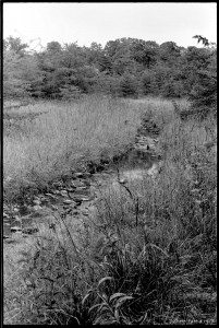
Stream in Soldiers Delight. I can't remember where this is. Fall 1973.
Stream in Soldiers Delight. I can’t remember exactly where this is. Fall 1973.

As a kid, my favorite thing about Soldiers Delight was playing in the streams. They were very different from all other streams I knew, which were muddy. In Baltimore County walking in a stream generally meant walking in mud. The water in Soldiers Delight streams was clear, and the stream bottoms were mostly stoney. The stream banks were also grassy and sunny. Streams elsewhere could be sunny, but even managed streams through pastures or parks were often lined with a thicket of woody plants. At Soldiers Delight long stretches of streams were lined only with tall grasses and wildflowers. Plus there were minnows and frogs and snakes. These were great streams. Continue reading “Buddles”

Chatanika Dredge

Radio Control
I flipped the joystick 1200 times to trigger the shutter (the 4 GB SD card filled up 10 minutes before I pulled it down).
The S95 captured 1170 photos in 1.5 hours while the Fled flew over the relic Gold Dredge #3 of the Fairbanks Exploration Company (F.E. Company). It was built in place in 1927-1928 and dug its own pond which it moved around until 1958. Hundreds of acres of the Chatanika River valley were turned into these concentric ridges of tailings as the placer gravels were devoured by the floating dredge and disgorged by the systematic arcs of its conveyor arm. Continue reading “Chatanika Dredge”

Unexpected Panorama

KAP over the Kame terrace from Petri's field
Note the Henry's Handle hanging from the belt. The kite line is cleated to that while I attach the Picavet and run through the pre-launch checklist.
The huge kame terraces in my town support a dry-tolerant forest of oaks, beech, and red maple, and as the new leaves emerge it is easier to tell the species apart at a distance. So I have been hoping to fly a kite over the terraces in early May and see if the trees delineated the terraces. The wind was gusty today, but it was supposed to calm down a bit in the afternoon, so I hiked up the hill and launched the nine foot Levitation delta. It was after 6:00 PM when I first triggered the S95 with the Futaba transmitter, and the light was wonderful even if the wind was not. It mostly cooperated until it slowed down enough to send me running upwind barely fast enough to keep the line out of the trees. But I had 900 feet of line out for a while and the camera was well out of the clearing were it could see the tree tops as I never had. Continue reading “Unexpected Panorama”

Return to the Nubble

I went over to the Adirondacks last Wednesday and came back with 1900 photos. Most of them were taken by my Gigapan imager, and half of those are duplicates that will never again see the light of day. Before I even got to New York, I took 126 handheld photos from the Lake Champlain ferry, 48 of which got stitched into the three-row panorama below of the new Crown Point Bridge, still under construction. Back on August 26, the day the central “network tied arch” was lifted into position, I came to repeat the gigapan I took of the old bridge. But the place was crawling with gawkers, and the men in hard hats would not let me get to the place from which the earlier panorama had been taken. So I left defeated. If you missed it too, you can relive the raising of the arch with the fully archived construction webcams, but you have to click through a lot of photos to get to 3:30 PM on August 26 when the action started. Continue reading “Return to the Nubble”

Giant Mountain

Somehow I convinced myself that the 4626 foot summit of Giant Mountain in the Adirondacks would be a good place to take some photos with a camera hanging from a kite. Yesterday I walked up there with two kites, three cameras, two KAP rigs, 1000 feet of line, and one sandwich. I think it might be possible to fly a kite up there sometime, but most of the time the wind on a mountain peak is not just blowing horizontally, it is moving up slope. This was obvious when I easily got the delta kite in the air from the summit and it tried to fly into the wind, over my head, and down the slope behind me. I realized that kites are designed to fly in wind that is perpendicular to gravity. When this geometry is lost, erratic behavior results, and the kite landed in a tree twice. Continue reading “Giant Mountain”

Photosynth Thesis

A couple of weeks ago I took some photos and video from the KAP rig lofted on the Flow Form 16 kite above a clearing behind the house. I did not get far stitching the images into a panorama, and had to move on to other business. Since then I have used Photosynth, which will not only display stitched panoramas, but the multiple unstitched overlapping images. The photos do not need to be taken from the same place, so KAP images should be well suited. Photosynth will create and display a 3D model of the surfaces in the photographs. The model consists of the points that Photosynth has determined are shared in two or more photos, and the 3D plot of those points based on photogrammetric analysis of the images. You can toggle a display of the point cloud in the Photosynth viewer below. Continue reading “Photosynth Thesis”

Town Forest KML tour

Below is an embedded Google Earth KML tour which introduces the relationship between the Salisbury Town Forest and some glacial features.

Below is an embedded Google Earth KML tour which introduces the relationship between the Salisbury Town Forest and some glacial features. It includes a two minute flying tour with audio narration. Your computer must have the Google Earth browser plugin installed to play the tour.

Click here to open the KML tour in a new browser tab. Then click the “Play Tour” button (upper right) to start the tour. Your computer must have the Google Earth browser plugin installed to play the tour. (Note: If you enter a gigapan, the “Exit Photo” button is partly hidden under the “Terrain” button. Click the exposed edge of it to exit the gigapan.)

The controls at the lower left of the tour window can be used to stop and start the tour, and when the tour is stopped you can navigate around the landscape and view the photos and gigapans. The links within the gigapan popups are not a good way to view the gigapans. Continue reading “Town Forest KML tour”

Kame terrace KML tour

Below is an embedded Google Earth KML tour which introduces some features of KML tours.

Below is an embedded Google Earth KML tour which introduces some features of KML tours. It includes a two minute flying tour with audio narration.

The controls at the lower left of the tour window can be used to stop and start the tour, and when the tour is stopped you can navigate around the landscape and view the photos and gigapans. The links within the gigapan popups are not a good way to view gigapans.

Click here to open the KML tour in a new browser tab. Then click the “Play Tour” button (upper right) to start the tour. (Note: If you enter a gigapan, the “Exit Photo” button is partly hidden under the “Terrain” button. Click the exposed edge of it to exit the gigapan.) Continue reading “Kame terrace KML tour”

Kame Terrace video

The 11.5 minute video below describes some geomorphological features at the eastern edge of the Champlain Valley in Vermont. It includes video animations made in Google Earth and saved as video files using the Movie Maker tool in Google Earth Pro. To watch in HD, go to Vimeo. Continue reading “Kame Terrace video”