Tag: Salisbury
Practice
Go Orioles!
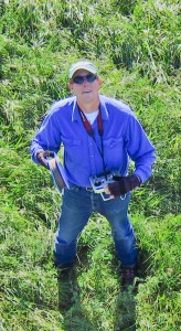
A month ago, on May 10, I noticed a wad of dry grass in the birch tree outside my home office window. It was obvious what it was, and a noisy pair of Baltimore orioles soon confirmed that a nest was being constructed. Four days later the nest building seemed to be mostly completed, and I stopped taking photos (click them to enlarge).
Unexpected Panorama
Built to fly
I awoke this morning to see that not a leaf on the hornbeam was fluttering, and my head fell back to the pillow in dismay. This was a sure sign that I had a new hobby. It was the KAPer’s lament: no wind. I had flown a camera on a kite for two days in a row, and the thought of a calm day was discouraging. But I had started a stitch of yesterday’s aerial panorama before I went to bed, so I got up two hours before Galen had to be at school to check on it.
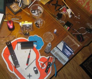
I built my first KAP rig last week from one of Brooks Leffler’s kits. I have never built anything with servos and dip switches and carbon fiber legs, but I got to use my Dremel tool, so it felt safe. Brooks has designed an elegant system for suspending a camera so that it can point in any direction. The pointing and shutter release are done either at predetermined intervals (autoKAP), or by radio control from the ground. The kit I built had servo motors for both panning and tilting and electronics to automatically point in as many as 76 directions and take photos potentially covering a downward-looking half-spherical view. By replacing the tiny circuit board with a radio receiver, the motors and shutter could be controlled via a transmitter on the ground. It is based on the RC airplane/car/boat/helo standards, so compatible equipment is readily available.
.
Beyond Prezi
Today I presented some preliminary results of a five-year winter wildlife tracking project my town’s conservation commission has just completed. I was part of a workshop on wildlife connectivity at the Vermont Statewide Conservation Conference in Rutland.
We had some spatial analysis and mapping of the tracking done by Kevin Behm at our county’s regional planning commission, and I wanted to display the mapped results in a compelling way. Google Earth was an obvious candidate for display, but driving Google Earth for a live audience is asking for trouble unless the show is simple. So I used the Movie Maker tool in Google Earth Pro to record three minutes of video highlighting the non-simple results and their context. Continue reading “Beyond Prezi”
Creepy and Cute
In Pittsburgh at the Fine International Conference on Gigapixel Imaging for Science in November, there will be a gallery show in the Carnegie Museum of Natural History of huge prints of eight gigapixel images. One of these will be a gigapan of my backyard patch of bergamot surrounded by an unnatural swarm of Ruby-throated Hummingbirds. You can see the gigapan here. The detail included below is about 4% of the area of the entire gigapan which will be printed about six feet wide.

Click the image to enlarge.
Town Forest KML tour
Below is an embedded Google Earth KML tour which introduces the relationship between the Salisbury Town Forest and some glacial features.
Below is an embedded Google Earth KML tour which introduces the relationship between the Salisbury Town Forest and some glacial features. It includes a two minute flying tour with audio narration. Your computer must have the Google Earth browser plugin installed to play the tour.
Click here to open the KML tour in a new browser tab. Then click the “Play Tour” button (upper right) to start the tour. Your computer must have the Google Earth browser plugin installed to play the tour. (Note: If you enter a gigapan, the “Exit Photo” button is partly hidden under the “Terrain” button. Click the exposed edge of it to exit the gigapan.)
The controls at the lower left of the tour window can be used to stop and start the tour, and when the tour is stopped you can navigate around the landscape and view the photos and gigapans. The links within the gigapan popups are not a good way to view the gigapans. Continue reading “Town Forest KML tour”
Kame terrace KML tour
Below is an embedded Google Earth KML tour which introduces some features of KML tours.
Below is an embedded Google Earth KML tour which introduces some features of KML tours. It includes a two minute flying tour with audio narration.
The controls at the lower left of the tour window can be used to stop and start the tour, and when the tour is stopped you can navigate around the landscape and view the photos and gigapans. The links within the gigapan popups are not a good way to view gigapans.
Click here to open the KML tour in a new browser tab. Then click the “Play Tour” button (upper right) to start the tour. (Note: If you enter a gigapan, the “Exit Photo” button is partly hidden under the “Terrain” button. Click the exposed edge of it to exit the gigapan.) Continue reading “Kame terrace KML tour”
Kame Terrace video
The 11.5 minute video below describes some geomorphological features at the eastern edge of the Champlain Valley in Vermont. It includes video animations made in Google Earth and saved as video files using the Movie Maker tool in Google Earth Pro. To watch in HD, go to Vimeo. Continue reading “Kame Terrace video”
