Very few Sitka alders established during the first two decades after the retreating Muir Glacier exposed my youngest study site (Site 1) at Glacier Bay. Older sites in Muir Inlet had abundant alder plants by the time the surface was 20 years old, and it seems likely that the difference was caused by a shortage of alder seeds arriving at the young site. Today there are a few alders at Site 1, and what they have done (or not done) in the last three decades suggests a more nuanced explanation.
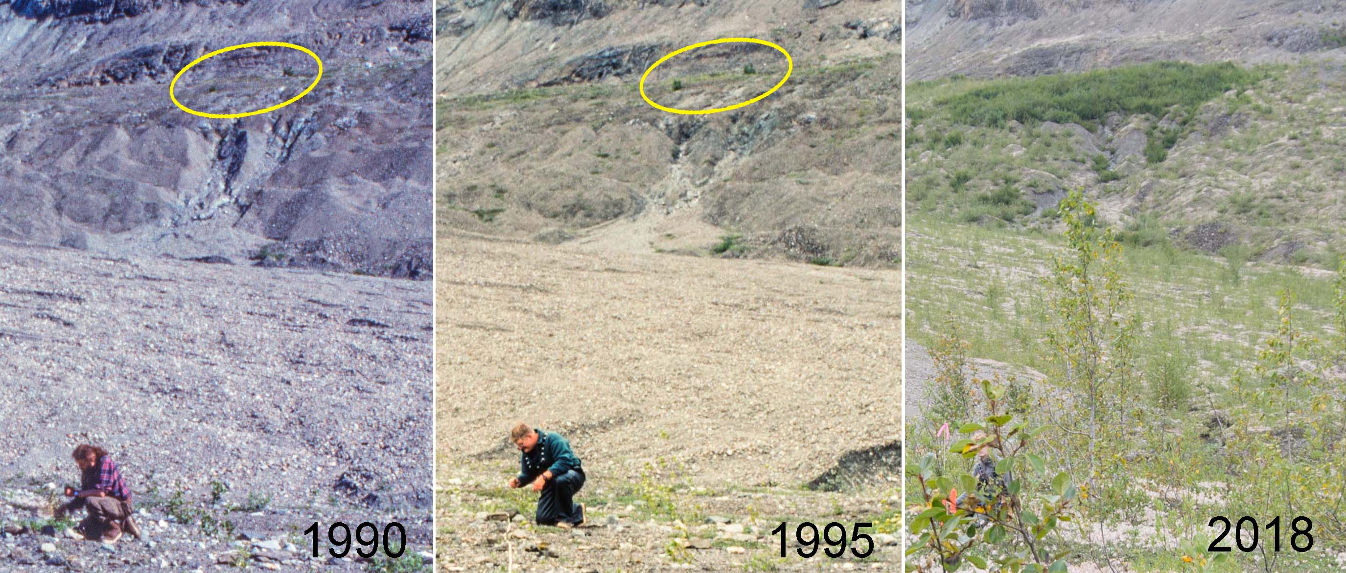
View from Plot 1 at Site 1 in three different years. Two Sitka alder plants visible in 1990 (ellipse) produced seeds which formed an island of alder 80 m across by 2018.
The young vegetation on the north side of Upper Muir Inlet in Glacier Bay National Park is developing dramatically differently from older vegetation a few km away. Today, five decades after the retreating Muir Glacier exposed my youngest study site (Site 1) to plant invasion, it supports an open shrubland of willows with most of the ground still carpeted with low-growing Dryas drummondii. At the same age (in 1995), the next older site (Site 2) had no Dryas and was a dense thicket of 6 meter tall Sitka alder shrubs. The distinct successional pathways being followed at these sites have critical ecological differences (e.g., alder is an important nitrogen fixer) and suggest that inferring ecological change from a sequence of different aged sites in this part of Glacier Bay does not work.
Can seed rain explain this?
My favorite hypothesis to explain this is that early seed rain of alder differed between the two areas. Ice margins in Glacier Bay have been retreating to the north for almost three centuries, and invading newly exposed terrain requires that plants can migrate as fast as the ice retreats. Alder was apparently doing a good job of chasing the ice along most of Muir Inlet where my reconstructions of invasion histories at four study sites confirm that alder was an important early invader.
The Fled overflies as I reel it in. It has been 14 years since we set up our first study plots south of the Alaska Range. I just returned to Fairbanks from a week-long trip to re-census the plots located above the upper forest limit at the Canyon Creek and Monahan Flats sites. There were a few scattered spruce trees and a total of a few dozen spruce seedlings marked with numbered tags in the quarter-hectare plots in 1998. The trees have not changed much, and only 8 to 10% of the seedlings have died. The surprise was the number of new spruce seedlings that have established in 14 years. The NIR modified and normal A495 cameras with AuRiCo controller. Synchronous, vertical photos were taken every 16 seconds.Seedling density increased by a factor of 2.9x at Canyon Creek and 2.2x at Monahan Flats. The similarity between the two sites suggests that the seedling invasion may be widespread. These seedlings have a lot to endure before they become trees, but if similar numbers of seedlings continue to establish and many of them become trees, these plots will no longer be above treeline in 50 years.
I was able to get some aerial photos of most of the plots after I had marked each seedling with pink flagging. I flew a dual camera KAP rig with normal and infrared-modified cameras lofted by a kite. I will be experimenting with false color IR (NRG) and NDVI images which can be created with information from both cameras. Continue reading “Sprucing up the hills”
I flipped the joystick 1200 times to trigger the shutter (the 4 GB SD card filled up 10 minutes before I pulled it down).The S95 captured 1170 photos in 1.5 hours while the Fled flew over the relic Gold Dredge #3 of the Fairbanks Exploration Company (F.E. Company). It was built in place in 1927-1928 and dug its own pond which it moved around until 1958. Hundreds of acres of the Chatanika River valley were turned into these concentric ridges of tailings as the placer gravels were devoured by the floating dredge and disgorged by the systematic arcs of its conveyor arm. Continue reading “Chatanika Dredge”