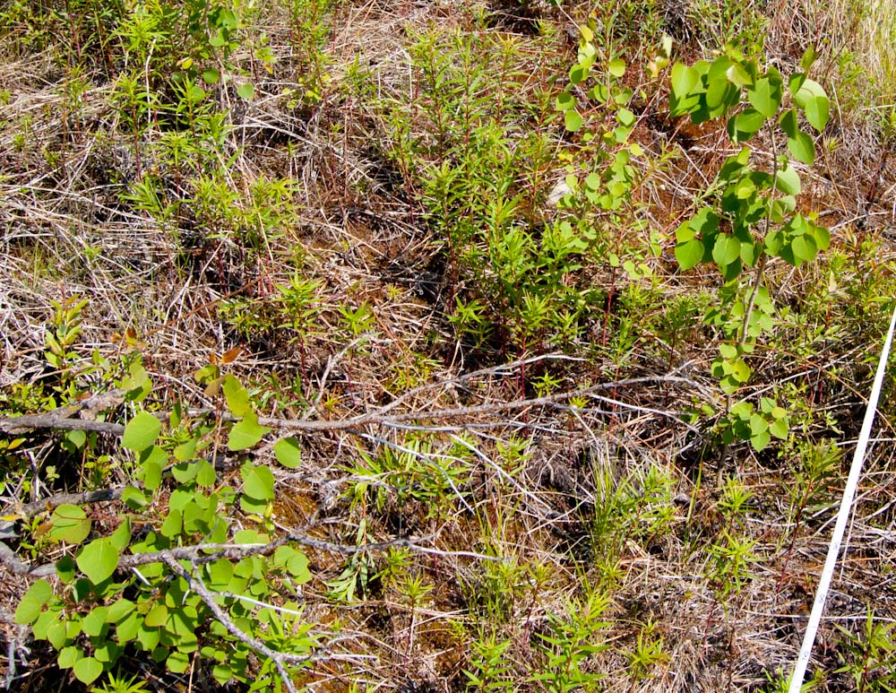
Giant Mountain

Somehow I convinced myself that the 4626 foot summit of Giant Mountain in the Adirondacks would be a good place to take some photos with a camera hanging from a kite. Yesterday I walked up there with two kites, three cameras, two KAP rigs, 1000 feet of line, and one sandwich. I think it might be possible to fly a kite up there sometime, but most of the time the wind on a mountain peak is not just blowing horizontally, it is moving up slope. This was obvious when I easily got the delta kite in the air from the summit and it tried to fly into the wind, over my head, and down the slope behind me. I realized that kites are designed to fly in wind that is perpendicular to gravity. When this geometry is lost, erratic behavior results, and the kite landed in a tree twice. Continue reading “Giant Mountain”

Little Tupper #5

Last weekend we made our fifth annual paddle trip to Little Tupper Lake with the same people, the same menu, and (as always) a new campsite. It was the second year we had to take a ferry from VT to NY instead of the Crown Point Bridge which is being replaced. The Photosynth panorama below of the new bridge was stitched from 12 handheld photos taken from the ferry at the dock.

I have made two Picasa albums from the trip. One has photos taken by a small camera attached to a kite line, and the other has photos taken by a DSLR which stayed close to, and more securely above, the lake surface. Below is a slide show from the KAP album. Continue reading “Little Tupper #5”

Bread Loaf

Me in a very open field, far from arboreal things which could ruin my day.
The replacement for the Fled arrived in the mail today. The Levitation Delta made by Into The Wind is not as interesting as the Fled (it is a classic triangular sail with central keel), but it is half the price and collapses to 30″ instead of 43″. And it is big — nine feet between wing tips. It does not have the stability of the Fled when the wind almost stops, but neither does it buck like the Fled, jerking forward in certain conditions. Late in the afternoon I took it up to the Bread Loaf Campus at 1400′ where I hoped there would be a breeze. It was light, but the delta flew very steadily, so I put the full autoKAP rig on flew it over toward the compound of old yellow buildings which are being prepared for Tuesday’s arrival of 250 students for the Bread Loaf School of English. The wind was variable, so the KAP rig did not stay in the same place for long and it was hard to find more than a few photos that would stitch together well. There are seven photos in the Photosynth panorama below. I am not sure what to do with the other 800. Continue reading “Bread Loaf”

Photosynth Thesis

A couple of weeks ago I took some photos and video from the KAP rig lofted on the Flow Form 16 kite above a clearing behind the house. I did not get far stitching the images into a panorama, and had to move on to other business. Since then I have used Photosynth, which will not only display stitched panoramas, but the multiple unstitched overlapping images. The photos do not need to be taken from the same place, so KAP images should be well suited. Photosynth will create and display a 3D model of the surfaces in the photographs. The model consists of the points that Photosynth has determined are shared in two or more photos, and the 3D plot of those points based on photogrammetric analysis of the images. You can toggle a display of the point cloud in the Photosynth viewer below. Continue reading “Photosynth Thesis”

The final flight of the Fled

Bird's eye view, Salisbury, VT
A postcard from ca. 1900 with a view of the village of Salisbury

Around the turn of the 20th century, a postcard was made with a view of the village of Salisbury, Vermont from a field on the side of a hill. Repeating this photo would highlight the dramatic changes since then, such as the draining of “Mirror Lake,” and the rampant increase in shade trees in the village. But trees also cover the hillside now, so it is not possible to reoccupy the original camera location. I have had this project in mind as I practiced kite photography, wondering how I could fly a camera over the trees close to the proper place. When Friday afternoon arrived sunny and breezy, I hopped in the truck and headed to Farwell Lookoff, the site of an old cabin at the top of that same (now forested) hill. I had been there only once before, and did not remember whether the cabin occupied a large enough clearing from which to launch a kite. The jury is still out on whether it does. Continue reading “The final flight of the Fled”

Built to fly

I awoke this morning to see that not a leaf on the hornbeam was fluttering, and my head fell back to the pillow in dismay.  This was a sure sign that I had a new hobby.  It was the KAPer’s lament: no wind. I had flown a camera on a kite for two days in a row, and the thought of a calm day was discouraging.  But I had started a stitch of yesterday’s aerial panorama before I went to bed, so I got up two hours before Galen had to be at school to check on it.

All the parts before assembly

I built my first KAP rig last week from one of Brooks Leffler’s kits. I have never built anything with servos and dip switches and carbon fiber legs, but I got to use my Dremel tool, so it felt safe.  Brooks has designed an elegant system for suspending a camera so that it can point in any direction.  The pointing and shutter release are done either at predetermined intervals (autoKAP), or by radio control from the ground.  The kit I built had servo motors for both panning and tilting and electronics to automatically point in as many as 76 directions and take photos potentially covering a downward-looking half-spherical view. By replacing the tiny circuit board with a radio receiver, the motors and shutter could be controlled via a transmitter on the ground.  It is based on the RC airplane/car/boat/helo standards, so compatible equipment is readily available.

.


Continue reading “Built to fly”

My Flying GigaPan

It took a couple of weeks for Jeffrey Warren’s message to sink in.  At first I thought his workshop on balloon aerial photography at the Fine gigapixel conference in November promoted a fringe pursuit – lofting cameras on tethered helium balloons to make better maps than were currently available.  But this pursuit emerged from the elegant convergence of modern camera technology and traditional lofting methods (balloons and kites).  It was now possible for anyone to make good, current “maps” from stitched, low-elevation vertical photographs.  Jeffrey is committed to inventing workarounds to the technological and financial obstacles that would otherwise put this process out of reach of the communities that might benefit from good maps.  This was the focus of his thesis at MIT, and he has had great success bringing communities together around these new map images and the experience of making them.  He has made the objective so compelling, and the process so simple and inexpensive that I soon realized I had to try it. Continue reading “My Flying GigaPan”

A clipboard-free zone

After it warmed up a bit yesterday, I tried out my new digital field protocol on a wildlife tracking transect behind my house. My goal was to record the identity, quantity, and location of large animal tracks in the snow which crossed the path I was walking (my “transect”). I am trying to develop a protocol for purely digital collection of these data.

Three types of data must be collected: date, location, and observation. The date (and time) is easy because most digital data has a time stamp. Collecting location data requires  a GPS enabled device. To collect the wildlife observation information in digital form requires manual data entry (keypad or touchscreen) or audio or video collection. I have seen some smart phone apps which could be bent to this purpose, but I don’t have such a phone, so the easiest route for me is audio, although this will require later translation to textual data.

[Update: I abandoned this three-device protocol after a few trials and now use only the GPS to make waypoints for each observation. The new method is described here.]

Linking the GPS data with the audio observations is the hard part. There are mature protocols for attaching GPS coordinates to image files, but not to audio files, although it should be easy to implement this on a smart phone. I used a digital photo as a link between the GPS data and the audio file. A key component of my protocol is a program which attaches GPS coordinates to photo files and can also associate an audio file with each photo. The program can also create a KMZ file or GIS shapefile which includes the georeferenced audio files. The program is RoboGeo which costs $80. This is the program that I use to georeference photos that I have taken while the GPS is recording a tracklog. Continue reading “A clipboard-free zone”

It’s a flock! A crowd! No, a herd!

A few days ago the Wired Science blog at Wired.com embedded the gigapans from the juried gallery show at the Carnegie Museum of Natural History. The same content also appeared at the Wired Science Japan site, so I used some online translators to see what had been written in Kanji about my hummingbird gigapan.

Here is the text that first appeared at the Wired Science blog:

Don’t let the 40 or so hummingbirds in this panorama fool you. There are really only two. Photographer Chris Fastie called it a “perplexing distortion of reality.” He took 78 photos over the course of a few minutes, then selectively merged them to capture multiple feeding and flying positions of the birds. “Rarely will the local male allow birds other than his mate to use a food source in his territory, so a feeding flock like this is impossible,” Fastie wrote on GigaPan.org.

This caption is a bit of a “perplexing distortion” because: (1) there are only 28 hummingbirds in the image, not “40 or so,” and (2) the 78 photos taken by the Gigapan imager did not include any birds.  An additional 28 photos of hummingbirds (and two of insects) were pasted onto the stitched panorama. This misinformation is partly my fault because my original caption at gigapan.org was not very explicit.  So the people hired to do the translation were already at a disadvantage, like the third person in a game of “telephone.” Continue reading “It’s a flock! A crowd! No, a herd!”

Fine Conference

The Fine International Conference on Gigapixel Imaging for Science is winding down and I am really looking forward to the cocktail reception when today’s poster session ends. There is also going to be a raffle for a Gigapan Epic Pro, so there is still much to look forward to.

It has been a real joy to meet lots of people who I knew only through their work online at gigapan.org, many others whose work I hope to know soon, and all the media people who might be incorporating gigapans into their work. It was tremendous fun to see dozens of members of the gigapan community whom I met 18 months ago at my first Fine Outreach for Science Workshop. I have really enjoyed interacting with many people who are more obsessed with gigapixel imaging than I am.

The proceedings papers are now online at http://gigapixelscience.gigapan.org/. A higher resolution PDF of my paper is here. All the presentations were videotaped, so maybe they will be online at some point so I can see the concurrent talks I missed. [UPDATE: Video of my presentation at YouTube.]

The Prezis for my conference talk and the one for my Fine Outreach for Science talk are available online at Prezi.com. These are somewhat sparse in the sense that they are not very self-explanatory, but you might glean something from them if you attended my talks.   Here is the motion bubble chart of my gigapan history that I used in the FOFS Workshop. And here is the kml file of Miss Pixie so you can see the Google Earth verification of the map I made of her locations. Here is a pioneering paper by Adam Dick et al. about mapping trees from 360° panoramas.

Thanks to the GigaPan teams for the tremendous effort they put into this event. It was a huge success.

Ledge

I never heard the term “ledge” used as a synonym for bedrock before I moved to Vermont. But I once heard a guy in Maryland confirm it was bedrock by saying “Yeah, I think that’s a piece of the state.”

Here is a Google Earth KML file of two ledgey places I visited this week. One was made of Monkton quartzite with some dolomite strata and a rich, unusual plant community, and I accompanied some experts who identified three state endangered species. The other was made of Cheshire quartzite with somewhat less calcium available, and I recently found a lovely grove of pitch and red pines there. A new gigapan of that Pitch Pine-Oak-Heath-Rocky Summit community is included in the KML file.

You can see photos, GPS tracks, and the gigapan by downloading the KML file into Google Earth, or by clicking the link (below the break) to open it in a new browser window, or just use the embedded window at the bottom of the post (Your computer must have the Google Earth browser plugin installed). Continue reading “Ledge”

Creepy and Cute

In Pittsburgh at the Fine International Conference on Gigapixel Imaging for Science in November, there will be a gallery show in the Carnegie Museum of Natural History of huge prints of eight gigapixel images. One of these will be a gigapan of my backyard patch of bergamot surrounded by an unnatural swarm of Ruby-throated Hummingbirds. You can see the gigapan here. The detail included below is about 4% of the area of the entire gigapan which will be printed about six feet wide.

The image integrates moments during three different visits by a male and female hummingbird.

Click the image to enlarge.